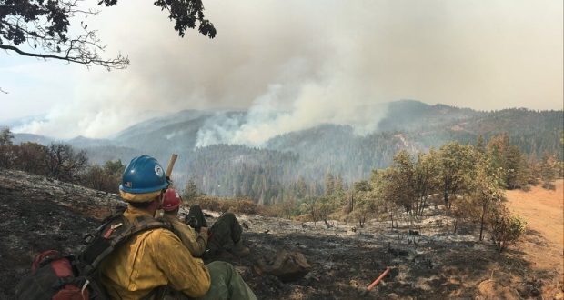
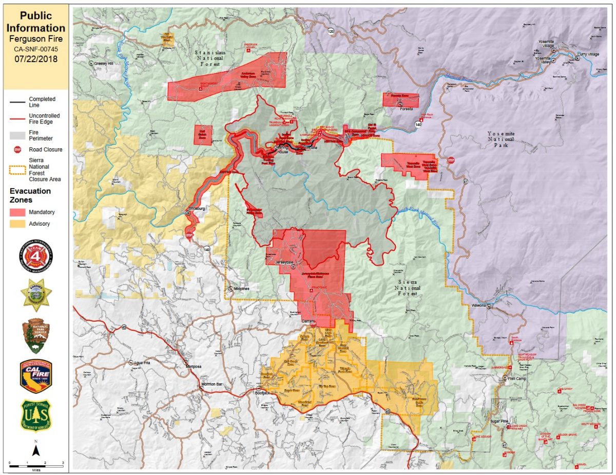
MARIPOSA COUNTY – The Ferguson Fire was active on most every front Saturday as it grew to 30,493 acres. It is just 6 percent contained.
The number of personnel assigned to the incident has increased to 2,903, including 204 engines, 72 crews, 42 dozers, 38 water tenders, 17 helicopters, and fixed-wing aircraft as conditions allow.
Most of the new line complete over the past 24 hours has been in the Jerseydale area.
Firefighters attempted a direct attack on the portion of the fire burning on the Stanislaus National Forest north of the Merced River, but terrain and fire behavior forced them to back off midday as conditions grew too dangerous to safely engage.
Crews have scouted and plan to use road systems around the Soapstone Ridge/ Ned’s Gulch vicinity as their holding line.
Firefighters also worked to install hose lays throughout the northeast and east containment lines to provide direct and indirect protection to El Portal and Yosemite West.
Burnout operations in the Sweetwater Creek area have been successful and continue to progress.
The forecast is for hotter and drier weather over the next few days, but most of the fire activity and behavior is dominated by the thick fuels and rough topography of the area.
There are 216 structures threatened by the Ferguson Fire, but none have been damaged or destroyed.
There have been four firefighter injuries reported. There has been one fatality on the fire.
There will be a celebration of the life of Cal Fire Heavy Fire Equipment Operator Braden Varney on Monday, July 23, in Modesto. On Sunday, July 22, from 2 to 6 p.m., there will be a visitation, open to the public, at Franklin & Downs Funeral Home, 1050 McHenry Ave in Modesto.
The Incident Command Post for the Ferguson Fire is now at the Ahwahnee Hills Regional Park. Please be aware of heavy fire equipment moving through the area.
The fire is under Unified Command with Cal Fire, U.S. Forest Service, Yosemite National Park and the Mariposa County Sheriff’s Office. Management of the fire transitioned to a Type 1 Management Team – California Team 4 on Thursday.
The Glacier Point Road inside Yosemite National Park has been closed to accommodate firefighting resources and activities at a small base camp located at the Yosemite Ski and Snowboard Area (formerly Badger Pass) and Bridalveil Creek Campground (which is also closed).
Though the west entrance (El Portal) to Yosemite National Park on Highway 140 is closed, the park remains open. For information on Yosemite National Park, go to nps.gov/yose or call 209-372-0200.
The Ferguson Fire started on Friday, July 13, at 8:30 p.m. The cause remains under investigation.
Smoke from the Ferguson Fire is impacting the Mariposa County Air Pollution Control District and across the region. For information specific to Mariposa County visit http://www.mariposacounty.org/index.aspx?NID=1434. For additional information on air quality you can visit the AirNow website or the air fire smoke page.
Residents can check the San Joaquin Valley Air Pollution Control District’s wildfire page at www.valleyair.org/wildfires for information about any current wildfires and whether they are impacting the Valley. The District’s Real-time Air Advisory Network (RAAN) provides localized air quality data from an extensive air-monitoring network which allows Valley residents to track PM at any Valley address by visiting myraan.com.
Evacuations
Mandatory evacuations are in place for:
- Savage Trading Post
- Redbud Lodge
- Cedar Lodge
- Indian Flat Campground
- Mariposa Pines
- Sweetwater Ridge
- Ferguson Ridge
- Jerseydale including all residences on Jerseydale Road, Hites Cove Road and all side roads from Triangle Road to the end of Hites Cove Road
- Incline Road from Clearing House to the Foresta Bridge in El Portal
- The BLM campgrounds in Briceburg are closed until further notice
- El Portal Trailer Park
- Old El Portal
- Rancheria Flat- Government Housing
- Foresta
- Yosemite View Lodge
- Yosemite West
- Anderson Valley
Advisories have been issued for the following locations:
- Lushmeadows Community
- Ponderosa Basin Community
- Triangle Road from Jerseydale Road to Highway 49 South including all side roads
- Darrah Road from Triangle to Sherrod Road
- East side of Highway 49S from Darrah Road to Harris Cutoff Road – This includes Boyer Road, Woodland Area, Wass Road and Tip Top Road
- Old Yosemite
These areas are NOT under a mandatory evacuation order. This is an advisement only of a potential evacuation order should conditions change.
Should these areas come under a mandatory evacuation order you will be notified via the Sheriff’s Office Emergency Alert System by text, email and a voice call, the Mariposa County Sheriff’s Office Facebook page, and door-to-door communication by Sheriff’s Office staff. At that time you will be notified of the best routes of travel to safely evacuate your residence.
The following Red Cross locations are open to assist anyone affected by wildfires:
A Red Cross Evacuation Center has been established at the New Life Christian Church located at 5089 Cole Road in Mariposa. If you have been evacuated due to the Ferguson Fire, the Sheriff’s Office asks that you please check in with the Red Cross Shelter even if you do not plan to stay there.
A second Evacuation Center has been opened to further accommodate those affected by the Ferguson Fire, located at Yosemite Valley Elementary School, 9009 Lost Arrow, in Yosemite Valley.
If you are in a Mandatory Evacuation or Advisory Area and may require assistance with evacuation transportation due to special needs or medical issues, please contact Human Services toll free at 1-833-423-0816 as soon as possible.
Planning ahead will help with a safe and timely evacuation.
Animal Evacuation Centers
Small Animal Shelter is at SPCA of Mariposa County, 5599 Highway 49 in Mariposa.
Large Animal Shelter is at the Mariposa County Fairgrounds, 5007 Fairgrounds Road in Mariposa.
Road Closures
Also closed are Jerseydale Road, Hites Cove Road and all side roads from Triangle Road to the end of Hites Cove Road; River Road from Briceburg to the gate at Railroad Flat and all campground areas are closed; Hites Cove Road from Bear Clover Road to the Merced River.
Cooperating Agencies include the Mariposa County Sheriff’s Office, Madera County Sheriff’s Office, CAL OES, California Highway Patrol, Caltrans, California Department of Corrections and Rehabilitation, American Red Cross, National Weather Service, California Conservation Corps, BLM and additional agencies throughout the state.

We know a couple from our church that have a cabin in the Mariposa Pines area on Hites Cove road, and the fire went north around that area the back down south again to the east of their cabin. A big thank you to the fire fighters, and God’s mercy in sparing all the homes and vacation cabins there. Hope and pray that they get this monster fire under control fast.