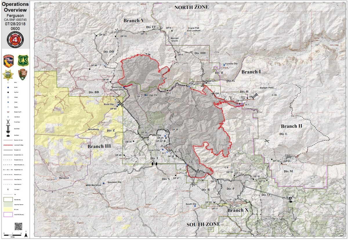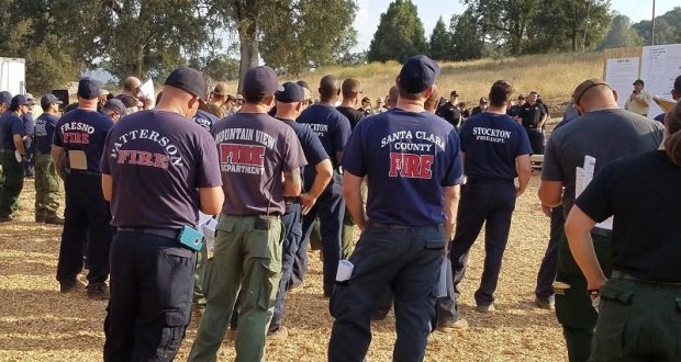
MARIPOSA COUNTY – Firefighters from across the region continue to battle the Ferguson Fire, which grew nearly 3,000 acres overnight and is now estimated at 49,619 acres. It is 29 percent contained.
Swirling, late afternoon winds southwest of El Portal spotted the fire across the lines yesterday. Firefighters were not able to reach that spot as of shift change this morning, and officials report it at just 3 to 5 acres. Crews monitored it throughout the night and will do direct attack today.
The night shift also prepared the area for a tactical firing operation to create a containment line along Henness Ridge southeast to Highway 41.
Yosemite National Park officials announced yesterday that the reopening of Yosemite Valley will be delayed until 4 p.m. on Friday, Aug. 3, and then with limited services.
Yosemite Valley has been closed since July 25 due to smoke impacts and for firefighting operations along El Portal Road and the Wawona Road (Highway 41) due to the Ferguson Fire.
Inside Yosemite National Park, work continues on the contingency lines between the burn scars from the 2017 Empire and South Fork Fires.
Along the northern perimeter, firefighters worked on a new containment line to shrink the big box on the portion of the fire burning on the Stanislaus National Forest, as the fire continues to move into Anderson Valley and Big Grizzly Creek.
To the south, firefighters secured containment lines around a fire that had jumped the line a few days earlier north of East Westfall Road.
Residents of Lushmeadows were allowed back in their homes Friday evening, however they remain in a fire advisement, meaning evacuations are possible if conditions change.
Officials estimate 5,245 structures are threatened by the fire, and just one non-residential structure has been destroyed.
There is now an estimated date for full containment of Aug. 15.
We will update with details of today’s activity on the firelines after tonight’s briefing.
There are currently 3,898 personnel assigned to the incident including 282 engines, 92 crews, 46 water tenders, 81 dozers, 16 helicopters, and fixed-wing tankers as conditions allow.
There have been seven firefighter injuries reported, and numerous instances of heat exhaustion-type symptoms. There has been one fatality on the fire.
Make sure you are signed up to receive alerts if wildfire or other emergencies threaten.
- To sign up for the Mariposa Sheriff’s Office Emergency Alert System visit https://local.nixle.com/register.
- To register for the Madera County Sheriff’s Office Emergency Alert System visit mcalert.org.
Yosemite National Park
Officials have announced that Yosemite Valley will reopen to all visitors at 4 p.m. on Friday, Aug. 3. Limited visitor services will be available inside Yosemite Valley, including campgrounds, lodging, and food service operations.
Yosemite Valley has been temporarily closed since July 25 due to smoke impacts and for firefighting operations along El Portal Road and the Wawona Road due to the Ferguson Fire.
The Mariposa Grove of Giant Sequoias and the Wawona Road (Highway 41) from the south entrance of Yosemite National Park to Tunnel View will remain closed until further notice.
The Hetch Hetchy area remains open. The Big Oak Flat Road (Highway 120 West) to Crane Flat and Tioga Road (Highway 120 East) from Crane Flat to Tioga Pass remain open to all visitors and vehicles. All trails and campgrounds along Tioga Road, including the Tuolumne Meadows Campground remain open. All visitor services along Tioga Road, including the High Sierra Camps and visitor services near Tuolumne Meadows remain open.
Since the Ferguson Fire began on Friday, July 13, several other park facilities and roads have been closed due to fire impacts and the need to support firefighting operations. These closures include Glacier Point Road, Bridalveil Creek Campground, the Wawona Campground, and the Merced Grove of Giant Sequoias.
Yosemite National Park continues to work closely with the Incident Management Team and continues to assess park conditions daily.
For updated 24-hour road and weather conditions for Yosemite National Park, please call 209-372-0200, press 1 and press 1 again. Updated information is also available on the park’s website at www.nps.gov/yose and on the Yosemite National Park Facebook page.
As of July 21, there are fire restrictions in place on the Sierra National Forest. Please read and be informed before you use any type of fire in the forest.
The Incident Command Post for the Ferguson Fire is located at the Ahwahnee Hills Regional Park. Please be aware of heavy fire equipment moving through the area. There is also a base camp set up at the ski area at Badger Pass.
The fire is under Unified Command with Cal Fire, U.S. Forest Service, Yosemite National Park and the Mariposa County Sheriff’s Office. Management of the fire transitioned to a Type 1 Management Team – California Team 4 on Thursday, July 19. For information about the fire please call 530-377-6221.
The Ferguson Fire started on Friday, July 13, at 8:30 p.m. The cause remains under investigation.
Smoke from the Ferguson Fire is impacting the Mariposa County Air Pollution Control District and across the region. For information specific to Mariposa County visit http://www.mariposacounty.org/index.aspx?NID=1434. For additional information on air quality you can visit the AirNow website or the air fire smoke page.
Residents can check the San Joaquin Valley Air Pollution Control District’s wildfire page at www.valleyair.org/wildfires for information about any current wildfires and whether they are impacting the Valley. The District’s Real-time Air Advisory Network (RAAN) provides localized air quality data from an extensive air-monitoring network which allows Valley residents to track PM at any Valley address by visiting myraan.com.
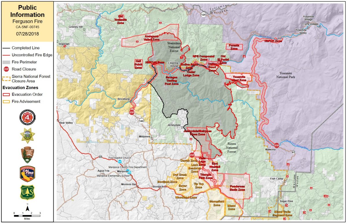
Evacuations
No new evacuations today.
New yesterday: Evacuations were lifted for the Lushmeadows area. Click here for details.
Mandatory evacuations are in place for:
- Savage Trading Post
- Redbud Lodge
- Cedar Lodge
- Indian Flat Campground
- Ferguson Ridge
- Incline Road from Clearing House to the Foresta Bridge in El Portal
- The BLM campgrounds in Briceburg are closed until further notice
- El Portal Trailer Park
- Old El Portal
- Rancheria Flat- Government Housing
- Foresta
- Yosemite View Lodge
- Yosemite West
- Anderson Valley
- Old Yosemite Road
- The north side of Triangle Road from Vista Lago to East Westfall and all side roads to the north
- The north side of East Westfall to Old Mill and all side roads to the north
- East Westfall Road to Chowchilla Mountain Road and all side roads
- Entire Ponderosa Subdivision
- Triangle Road from Darrah Road in the Lushmeadows area to Highway 49 South and all side roads
- Tip Top Road from Triangle Road to Gunther Road including Gunther Road
Advisories have been issued for the following locations:
- Darrah Road from Triangle to Sherrod Road
- East side of Highway 49S from Darrah Road to Harris Cutoff Road – This includes Boyer Road, Woodland Area and Wass Road
- Mariposa Pines on Scott Road from Best Road to the end of Hites Cove Road, including all side roads
- Highway 49 South from Stumpfield Mountain Road to the Mariposa/Madera County Line including Kimble Road
- Stumpfield Mountain Road
- Watt Road
- Lushmeadows
- Jerseydale and Sweetwater Ridge Road
These areas are NOT under a mandatory evacuation order. This is an advisement only of a potential evacuation order should conditions change.
Should these areas come under a mandatory evacuation order you will be notified via the Sheriff’s Office Emergency Alert System by text, email and a voice call, the Mariposa County Sheriff’s Office Facebook page, and door-to-door communication by Sheriff’s Office staff. At that time you will be notified of the best routes of travel to safely evacuate your residence.
A Red Cross Evacuation Center has been established at Mariposa Elementary School at 5044 Jones Street in Mariposa. This shelter is accepting small pets with their owners.
The shelter at Mountain Christian Center at 40299 Highway 49 in Oakhurst has been closed due to lack of need by evacuees. They remain on standby and will reopen if conditions warrant.
The shelter at New Life Christian Church located at 5089 Cole Road in Bootjack has been closed.
If you have been evacuated due to the Ferguson Fire, the Sheriff’s Office asks that you please check in with the Red Cross Shelter even if you do not plan to stay there.
If you are in a Mandatory Evacuation or Advisory Area and may require assistance with evacuation transportation due to special needs or medical issues, please contact Human Services toll free at 1-833-423-0816 as soon as possible.
Planning ahead will help with a safe and timely evacuation.
Animal Evacuation Centers
Small Animal Shelter is at SPCA of Mariposa County, 5599 Highway 49 in Mariposa is at full capacity.
Residents with small pets can be accommodated at the Mariposa Elementary School Shelter at 5044 Jones Street for those under mandatory evacuation, where Central California Animal Disaster Team (CCADT) is operating an emergency animal shelter. You must check in with Red Cross first. Please try to accommodate your pets with family and friends first, however your pet is welcome to be sheltered if necessary at the Mariposa Elementary School. For questions about pets, please call CCADT at 888-402-2238 ext. 0, and leave a message. Someone will return your call as soon as possible.
Large Animal Shelter is at the Mariposa County Fairgrounds, 5007 Fairgrounds Road in Mariposa.
Road Closures
Highway 140 is closed from the El Portal entrance gate to 14 miles north of Mariposa.
Wawona Road (Highway 41) between Chilnualna Falls Road in Wawona and Bridalveil Fall Road in Yosemite Valley were closed beginning at noon on July 25.
Also closed are:
- Triangle Road, from Darrah Road to Highway 49 south and all side roads
- Chowchilla Mountain Road at Highway 49 south
- Harris Road at Highway 49 south
- Tip Top Road from Triangle Road to Gunther Road
- All roads inside Ponderosa Basin Subdivision
- Hites Cove Road from Bear Clover Road to the Merced River
- River Road from Briceburg to the gate at Railroad Flat and all campgrounds
- Anderson Valley Road
- Old Yosemite Road
Cooperating Agencies include the Mariposa County Sheriff’s Office, Madera County Sheriff’s Office, CAL OES, California Highway Patrol, Caltrans, California Department of Corrections and Rehabilitation, American Red Cross, National Weather Service, California Conservation Corps, BLM and additional agencies throughout the state.