Favorite Dog Hikes of SNO Readers
Thank you to the SNO readers who shared their favorite dog hikes with me. I look forward to adding more to this “living document” as more come in. I have included some basic information on these dog hikes and purposefully did not include detailed information on health, safety and conditioning related to hiking with your dog as that information can easily be obtained other places. When hiking with your dog, responsible dog owners should practice the same “Leave No Trace” as we do when hiking without our dogs.
Maps of the hikes can be located off of the links below the hike, specifically the prior blog on the hike. You can contact me at candace@sierranewsonline.com with your hikes and suggestions.
Fresno County
San Joaquin River Gorge (Bureau of Land Management, San Joaquin River Gorge Special Management Area, Millerton Lake State Recreation Area)
Highlights: In the spring, the wildflower show is beautiful as you walk through the green grass and view the reflections in the San Joaquin River.
Elevation: 564 – 1,279′
Trail Information: Easy to Moderate. There are many trails to explore in this area, with plans to add even more. The San Joaquin River Trail will eventually be continuous for 100 miles from Highway 99 to the headwaters of the river at Devils Postpile. The trail will incorporate the 57-mile route developed by John French in 1879. The French Trail follows natural terrain used by the Mono Indians to cross the Sierra Nevada Mountains.
Directions: From North Fork, past Kerckhoff Lake then to Smalley Road then right at the BLM San Joaquin River Gorge Sign. Head down Smalley Road to the Ya-Gub-Weh-Tuh Trailhead and Campground. There is a well maintained outhouse here and picnic tables. There is also a $5 for day use with a self service payment system.
Dog Policy: Pets should either be leashed or under direct voice control.
Things You Should Know: Don’t be surprised to see cows grazing along the trail, so you want to make sure you have your dog in control. Other wildlife include Mountain Lions, Bobcats, Coyote and many others. Once the weather warms up, the snakes come out and there are many rattlesnakes in this area. Bicycles and horses also share the trail. In the winter and early spring, you may find natural water sources along the trail but not in summer. Depending on how far away you are hiking from the river, you may need to pack dog water.
Links:
BLM San Joaquin River Gorge Special Recreation Management Area (Note that at the time of this writing this website was down)
Prior Hike: Hiking the San Joaquin River Trail March 31, 2016
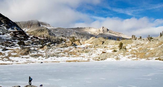
SNO-PARK East of Shaver Lake (Sierra National Forest)
Highlights: After a fresh snow, this area delivers a brilliant, bright blue sky and crisp white snow that highlight great views of the high peaks to the east and south. Snow covered hills give you a nice adventure with ever-changing views when you top out over each one of them. You can even capture a view into the Minarets.
Elevation: 7,286 – 7,899′
Trail Information: Easy to Moderate. There are several trails of varying length to explore in the SNO-PARK areas.
Directions: Head up Hwy 180 to Shaver Lake where you will need to pick up a parking permit. There are several places where you can do this and the Tamarack and Coyote links have that information. Day permits are sold for $5 and are valid for one single day. Season permits are sold for $25 and are valid for the entire SNO-PARK season (November 1 through May 30). Any vehicle parked at a SNO-PARK site without a permit properly displayed is subject to a $75 fine and they do fine. The funding from the permit sales provides plowed parking as well as sanitation facilities. You should also pick up a copy of the High Sierra Ranger District Winter Recreation Guide.
Dog Policy: Pets should either be leashed or under direct voice control. These SNO-PARKS provide an area for diverse winter fun, whether it is snowmobiling, cross country skiing, snowshoeing, sledding, or just playing in the snow and creating a great snowman! You may encounter any of these or none at all.
Things You Should Know: If you are hiking this in the, you will need to pack dog water. Wildlife includes Mountain Lions, Black Bears, Bobcats, and Coyote.
Links:
Guide to SNO-PARKS in California
Prior Hike: Tamarack Ridge Snowshoe Hike March 8, 2014
Twin and George Lakes (Sierra National Forest, Kaiser Wilderness)
Highlights: Hiking along beautiful meadows and clear blue alpine lakes with giant granite slabs surrounding them.
Elevation: 8,307 – 9,123′
Trail Information: Moderate, about 10 miles. For the first mile, the trail climbs gradually through mixed coniferous forest of Jeffrey pine and red fir before crossing the first of many creeks and meadows. Soon the trail traverses into the Potter Creek drainage, offering views of snow-capped Red Mountain. The trail arrives at 8,990-foot Potter Pass at mile 2, passing an unsigned trail heading back down the hill to Huntington Lake. You will see a Kaiser wilderness sign. To the northeast, you can see 13,157-foot Mt. Ritter, Banner Peak and the Minarets. From the pass, the trail descends steeply down the hill. After descending about 500 feet and 2.7 miles, the trail reaches another intersection. Go left toward Twin Lakes and you will arrive at the Lower Twin Lake at 3.3 miles. Upper Twin Lake is another .3 miles. If you follow the east shore of Upper Twin Lake to an intersection at the upper end then head left, up a short hill and toward the saddle on the Kaiser Ridge, then along a snaketrack of a trail another mile, you will reach George Lake.
Directions: Head east on Highway 168 past Huntington Lake, turning right onto Kaiser Pass Road. Continued 4.8 miles from the junction to the large trailhead parking with nice, clean restrooms on the south side of the road.
Dog Policy: Pets should either be leashed or under direct voice control.
Things You Should Know: In summer or dry years, you cannot count on dog water until you reach Lower Twin Lake. Wildlife includes Mountain Lions, Black Bears, Bobcats, Coyote and you could encounter an occasional rattlesnake at the lower elevations. This trail is shared by horses. You may want to bring your fishing pole along.
Links:
Prior Hike: Hiking up to Twin and George Lakes June 14, 2015
Madera County
Eastman Lake (U.S. Army Corps of Engineers)
Highlights: In the spring, wildflowers line the trail and Bald Eagles soar over the lake.
Elevation: 636 – 1,861′
Trail Information: Easy to Moderate, about 8 miles.
Directions: You can start this hike from either end of the 4 mile Lakeview Trail. Here are the directions if you start this hike at the upper Trailhead at the Raymond Bridge like we planned. Head north-ish at Raymond on Rd. 613 about 6 miles until you are at the Raymond Bridge which crosses the Chowchilla River. From Fresno take Highway 99 past Madera and exit to Avenue 20 ½ and turn right to stay on Avenue 20 ½ which turns into Avenue 21, continue straight as the road changes to the Raymond Rd. (Road 603) to Raymond. Turn left in Raymond to Road 613 and drive 5 miles to the Raymond Bridge where the Trailhead is located. This is the far upper end of the lake.
Dog Policy: Pets should either be leashed or under direct voice control.
Things You Should Know: Restrooms are available in the campgrounds at the lower end of the trail. Water on the trail can be scarce and this can be a warm hike even in spring. Wildlife includes Mountain Lions, Black Bears, Bobcats, Coyote and Rattlesnakes. The trail is shared with horse and bicycles.
Links:
Prior Hike: Hiking With Raven and Sally Along Eastman Lake February 24, 2016
Lewis Creek Trail (Sierra National Forest)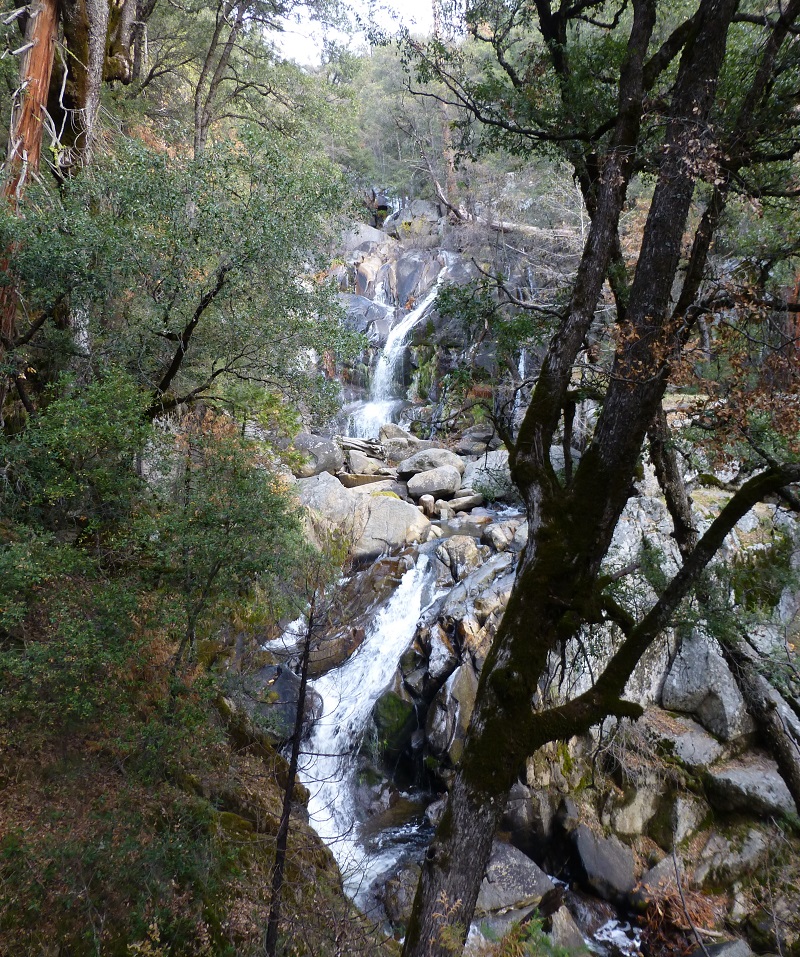
Highlights: Corlieu Falls is a beautiful series of falls reached by a shaded trail that follows Lewis Creek. The trail follows what was once the Sugar Pine Madera-Sugar Pine Lumber Company flume.
Elevation: 3,325 – 3,900′
Trail Information: Easy to Moderate. The Lewis Creek Trail (21E06) was designated part of the National Recreation Trails System in 1982. You can hike all or any part of this 3.5 mile length of Lewis Creek. There used to be a log bridge that crossed Lewis Creek just past the top of Corlieu Falls and if you turn around here, that will be about 4 miles roundtrip. Continuing on the Lewis Creek Trail, you can hop across Lewis Creek where the bridge used to be via rocks or down logs, or wade. If you cross, you can walk upstream to Red Rock Falls and Sugar Pine.
Directions: It can be accessed at three places: 1) on Cedar Valley Road, 1.1 miles from Hwy 41; 2) at the turnout on Hwy 4l,just beyond the “Elev 4000″‘ sign; 3) on Sugar Pine Drive, 0.6 miles from Hwy 41.
Dog Policy: Pets should either be leashed or under direct voice control.
Things You Should Know: Dog water should be available in Lewis Creek. Wildlife includes Mountain Lions, Black Bears, Bobcats, Coyote and Rattlesnakes. There is poison oak along the trail. This trail gets a little heavier visitor use than other hikes due to its proximity to Oakhurst, so you are more likely to encounter other hikers, some with their dogs. This trail is shared with horses in some portions.
Links:
Prior Hike: Hiking the Lewis Creek Trail to Corlieu Falls and Beyond December 7, 2016
Nelder Grove (Sierra National Forest)
Highlights: Nelder Grove consists of approximately 1,540 acres in the Sierra National Forest and one of the highlights are about 100 mature sequoias mixed in a forest of pine, fir and cedar. In the spring, dogwoods and azaelas blooming are magnificent. Fall delivers foliage that includes red dogwoods and yellow oaks. An Interpretive Center has log cabins from the 1880s, and if you download the Interpretive Guide and map from their website, you can take a self guided tour that includes history and props that explain the logging that took place in this area. The campground is open May through December.
Elevation: 4,700 – 6,280′
Trail Information: Easy to Moderate. Several trails that range from 1/10th of a mile to almost 4 miles can be looped together for more mileage.
Directions: From the south exit of Yosemite National Park: Drive south 12 miles and make a left turn onto road 632 – Sky Ranch Road. Coming from the south: Drive about 4 miles on Highway 41, north of Oakhurst, CA, and make a right turn onto road 632 – Sky Ranch Road. Drive for 7 miles. Turn left on dirt road 6S47Y, and drive about 1 mile. At the fork, turn left for Shadow of the Giants trail, 1 mile. Turn right for campground and other trails. Then turn left at 5S19. The campground/trails are about 1 mile from the fork.
Dog Policy: Pets should either be leashed or under direct voice control. When camping in areas with other visitors, pets should be kept on a leash.
Things You Should Know: Restrooms (PortaPotties) are located at the Interpretive Center and Campground. Potable Water is not available although depending on the time of the year the streams may have dog water. It’s a “trash in, trash-out” campground–“scoop the poop.” Lots of wildlife including Mountain Lions, Black Bears, Bobcats, Coyote and Rattlesnakes can be found in the area.
Links:
Prior Hike: Hiking from Nelder Grove to Kelty Meadow
Friends of Nelder Grove Website
The Canine Camper by Sierra National Forest
Resources:
Negley, Brenda L., Nelder Grove of Giant Sequoia: A Grandaughter’s Stories, Otter Bay Books, 2016
Photo by Keith Sauer
Norris Creek Trail/Lady Lillian Lakes (Sierra National Forest, Ansel Adams Wilderness)
Highlights: Beautiful high lakes nestled in granite mountains with views of the high country to the east as you climb. In the spring, wildflowers can be found along the way and if you hit it right in the fall, amazing red foliage dominates some areas along the trail. You can’t beat the reflections in the high lakes.
Elevation: 7,507 – 9,222′
Trail Information: Easy to Moderate. The Norris Creek Trail is the gateway to several different hikes to high lakes.
Directions: Off of Bass Lake Road, drive up Beasore Road, which turns into a pothole highway after it crossed Chilkoot Creek. Some parts of the road have a little bit of pavement on it in spots but it is more ruts, cracks, and craters than road. Some years are better than others, which also means that some years it can be pretty bad. A car could negotiate these potholes by slowly and carefully weaving its way and crisscrossing the road. Even then, your car will likely find some of them. I didn’t clock the exact mileage but it was about 40 miles up Beasore Rd. where the marked junction to the dirt road on the left will take you to the Norris Trailhead and another 2 miles or so up that dirt road, which was in good shape the last time I was up there. Park at the end of the road in the Norris Creek Trailhead parking area. The Trailhead has signs that you can’t miss.
Dog Policy: Pets should either be leashed or under direct voice control.
Things You Should Know: In the spring, dog water should be available in Madera Creek but it can be scarce in the fall. You may need to pack dog water in those conditions to tide you over until you make it to the lakes. Wildlife includes Mountain Lions, Black Bears, Bobcats, Coyote and you could run into an occasional Rattlesnake at the lower elevations. Stash your goodies in the bear boxes at the Trailhead. You may want to bring your fishing pole along.
Prior Hike: Hiking to Chittenden Lake September 20, 2016
Mariposa County
Photo by Debra Sutherland
Fish Camp/Big Sandy (Sierra National Forest)
Highlights: Heading up an old diversion ditch to small waterfalls and pools in Big Creek. I love doing this one on showshoes.
Elevation: 5,150 – 5,400 to Ditch intake at Big Creek, 6,140 to Big Sandy
Trail Information: Easy. About 5.5 miles roundtrip from the ditch intake. From the parking lot at the Tenaya Lodge head south and descend the short access road to intercept Jackson Road I Road 6S07 (“Big Sandy-5”). Walking east on 6S07 you pass riding stables at about 0.6 miles (the stables are in operation from mid-May to October). Continue to the signed road junction at 2.0 miles. The “Chinese Ditch” crosses the road here in a culvert and terminates just to the west at Lewis Creek. Tum left (east) here, pass an old cabin, and walk the narrow northern bank of the ditch–on material thrown up during excavation. The rushing water in the ditch and the forest shade make this a most pleasant walk on a warm spring day. In 0.5 mile you arrive at the ditch intake at Big Creek–just above an impressive waterfall. When the water is low you can cross Big Creek here and continue upstream to another, higher waterfall. Chinese Ditch can be combined with a hike on up Rd 6S07 to Big Sandy or Little Sandy campgrounds to make a longer hike. If going to Big or Little Sandy the hike can be shortened by driving further up Road 6S07 before parking.
Directions: Drive north on Hwy 41, just before entering Fish Camp turn right into the entrance to the Tenaya Lodge. Park in the lodge lot, away from the lodge entrance.
Dog Policy: Pets should either be leashed or under direct voice control. When camping in areas with other visitors, pets should be kept on a leash.
Things You Should Know: Wildlife including Mountain Lions, Black Bears, Bobcats, Coyote and Rattlesnakes can be found in the area.
Links:
Prior Hike: Snowshoe Adventure with Sally and Raven at Fish Camp November 17, 2015
Mono County
Bennettville (Inyo National Forest, Hoover Wilderness)
Highlights: Visiting the old mining town of Bennettville that was booming in 1880, along with the remains of nearby old mines such as the Great Sierra Mine, is worth the trip but you can extend the hike and head up mine creek by several beautiful high elevation lakes.
Elevation: 9,530 – 9,800 to Bennettville, 10,375 to Green Treble Lake
Trail Information: Moderate to strenuous. About 7 miles roundtrip to green Treble Lake. The trail to Bennettville climbs east through lodgepole pine forest. There are two old and restored wooden buildings at Bennettville. You can head west on a trail that crosses Mine Creek on a log bridge to the site of the Great Sierra Mine. At a fork, before crossing the creek, take the branch that heads north, up the east side of Mine Creek. Along the way pass Shell and Fantail Lakes to the end of the Mine Creek Valley. If you are venturing higher up, the trail isn’t quite as clear but you can find it by taking your time as you climb through the rocky are that leads you to Spuller Lake. Continuing up through a rocky and pass, you can descend to Maul Lake and Green Treble Lake. This is a nice spot for lunch and you can return the same way that you came in or head northeast and follow Lee Vining Creek back to the campground. You will cross old mining roads along the way and ponder who traveled them and where they were going.
Directions: Drive to Crane Flat, then take the Tioga Road for 4 7 miles to the Tioga Pass Park Entrance Station. Proceed for another two miles–Junction Meadow Campground is on the
left, by the road to Saddlebag Lake. Park near the bridge (before the campground). There is a sign here marking the trail to Bennettville.
Dog Policy: Pets should either be leashed or under direct voice control.
Things You Should Know: If the Junction Campground is open, there are bathrooms available there. Natural water sources have been plentiful. This area has wildlife such as Black Bears and coyote. There are signs warning about Bubonic Plague and the rocks can be tough on a dog’s feet, especially if they aren’t toughened up yet. I carry boots for my dogs, just in case.
Links:
Prior Hike: Hiking with Sally From Bennettville to Green Treble Lake August 18, 2016
Resources:
O’Neil, John Carroll, Tioga Tramps, Albicaulis Publishing, June 2002
Inyo National Forest Hiking and Camping with Dogs
Twenty Lakes Basin (Inyo National Forest, Hoover Wilderness)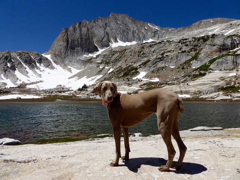
Highlights: This is a beautiful looped hike that visits several high elevation lakes with rugged red and white rocky mountains surrounding them.
Elevation: 10,120 – 10,310′
Trail Information: Moderate to strenuous. About 9.35 miles roundtrip if you walk it all, about 7.9 miles if you take the water taxi. The starting point for this hike is on the northwest shore of Saddlebag Lake, across the lake from the resort. To get there you can walk around the lake (1.5 miles by the west shore, 2.2 miles by the east shore) or you can ride the water taxi ($8 one-way and $13 round-trip for people, $5 one-way and $6 round trip for dogs in 2016).
Directions: Drive to Crane Flat, then take the Tioga Road (Hwy 120 east) for 47 miles to the Tioga Pass Park Entrance Station–two miles beyond, turn left on the road to Saddlebag Lake. It is three miles in to the lake where there is a campground, a store and a boat taxi service. Park in the backpackers lot or down near the store and boat ramp.
Dog Policy: Pets should either be leashed or under direct voice control. When camping in areas with other visitors, pets should be kept on a leash.
Things You Should Know: The Saddlebag Lake Resort is open in the summer, has a small General Store and Cafe. Their pies are really good! There is an Inyo National Forest campground adjacent to the resort. Natural water sources have been plentiful. This area has wildlife such as Black Bears and coyote. There are signs warning about Bubonic Plague and the rocks can be tough on a dog’s feet, especially if they aren’t toughened up yet. I carry boots for my dogs, just in case. Bring your fishing pole if you wish and you won’t be disappointed.
Links:
Saddlebag Lake Resort Home Page
Inyo National Forest Hiking and Camping with Dogs
Prior Hike: Hiking with Sally in the 20 Lakes Basin July 12, 2016
More Information Related to Hiking with your Dog:
Hiking or Backpacking with Your Dog REI
Last Updated December 16, 2016

