Home » Blogs » Adventures with Candace (page 28)

Adventures with Candace

Hiking with Sally from Saddlebag Lake through Twenty Lakes Basin

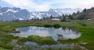
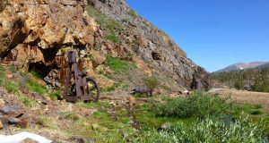
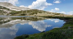
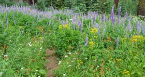
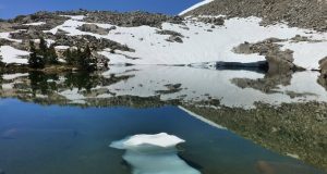
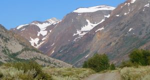
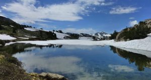
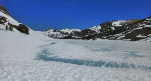
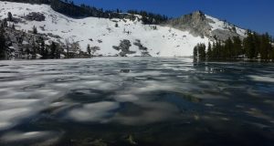
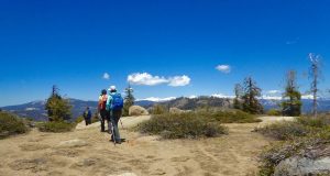
It is hard to believe that it is the middle of August and the snow up at the higher elevations is really hanging in there. Sally and I wandered our way through that snow in the Twenty Lakes Basin by beautiful lakes in the Hoover Wilderness. Where: Hoover Wilderness Distance: 10 Miles Difficulty: Moderate Elevation Range: 10,108′ – 10,342′ Date: ...

Read More »

Hiking up to Spillway and Helen Lakes

How much snow and ice would we find at the 11,000′ elevation above the Mono Pass Trail in August? It was the right time to get up there and check it out. It took us 5 hours and 44 minutes to do this hike but you can follow along on the hike with me on the Doarama link under Maps ...

Read More »

Hiking Bridalveil Creek Area with Wildflowers

Red, pink, white, orange, purple, tall and short flowers are all putting on a tremendous show right now in the meadows off of Glacier Point Road in Yosemite National Park. If you want to see an explosion of wildflower colors, get there now! Where: Yosemite National Park Distance: 13.46 Miles Difficulty: Easy to Moderate Elevation Range: 6,959′ – 7,622′ Date: ...

Read More »

Hiking up to Jackass and Burro Lakes

We headed cross country up to beautiful little lake, still partially covered with snow and ice, named Burro Lake. Along the way, our route took us by a creek with wildflowers of every color and incredible reflections in high lakes bordered by granite mountains. Where: Sierra National Forest, Ansel Adams Wilderness Distance: 9.57 Miles Difficulty: Moderate to Strenuous Elevation Range: ...

Read More »

Escape with Sally to Lundy Canyon

Dramatic high peaks, streaked with colors of red, white and brown and still capped with snow frame Lundy Canyon. Mill Creek was high and really moving, lined with aspens that lulled me to sleep as the wind moved through them. It was a perfect place for Sally and I to kick back and relax . . and maybe catch a ...

Read More »

Snowshoeing up to Gaylor, Granite Lakes and Dana City in July!

Snowshoeing in the Tioga Pass area in July? Yes indeed! How else could we travel across the solid snowfields full of suncups to some beautiful lakes and the old mining town of Dana City? Where: Yosemite National Park, Inyo National Forest Distance: 5.3 Miles Difficulty: Moderate Elevation Range: 9,945′ – 11,025′ Date: July 5, 2017 Map: Falls Ridge Quad Dog Hike? ...

Read More »

Tioga Road Opens and I am There!

When Yosemite National Park announced that Tioga Road (continuation of Highway 120 through the park) was to open on Thursday, June 29, at 8 am, you know I had to be there. We were at the spot on Tioga Road where the gate had been closed for the winter by 0741 and it was already opened! There were several signs ...

Read More »

Hiking to Ostrander Lake

Picture escaping the heat to icy Ostrander Lake, bordered by a snowy, rocky ledge. That is exactly what we did in the middle of June, watching the last of the winter ice melt away, creating beautiful reflections. Where: Yosemite National Park Distance: 12.56 Miles Difficulty: Moderate to Strenuous Elevation Range: 6,998′ – 8,613′ Date: June 20, 2017 Maps: El Capitan, ...

Read More »

Hiking up to Little Shuteye Peak

deb

We hiked off trail through brush, snow, crossing small creeks and swamps to get our reward of seeing a very rare flower and wonderful views of snowcapped high peaks. And, who knew that a small toad was a peak bagger? Where: Sierra National Forest Distance: 5.32 Miles Difficulty: Moderate Elevation Range: 7,188′ – 8,353′ Date: June 14, 2017 Maps: Little ...

Read More »
Sierra News Online

Sierra News Online