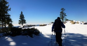
The recent snowfall was inviting us to our first showshoe adventure of the year. Except for the many animal tracks we could see in the snow, we had the place to ourselves. Where: Tamarack Ridge SNO-PARK, Sierra National Forest Distance: 4.8 miles Difficulty: Moderate Elevational Range: 7,446′ to 7,728′ Date: November 12, 2015 Maps: High Sierra Ranger District Winter Recreation Guide, Dinky Creek ...
Read More »Author Archives: Candace Gregory
Leaf Peeping in Yosemite Valley
We couldn’t wait to get up to Yosemite Valley right after the last storm. We needed to check out the fall colors, reflections in the Merced River, those waterfalls and snow covered trees on the rim. Plus, you never know what special surprise will be in store for us on our adventures. Difficulty: Easy Elevational Range: 3,880′ to 4,960′ Date: November 4, 2015 ...
Read More »Hiking with Sally up to the Hess Mine in the Tioga Pass Area
I had been looking at a dot on the topog map called the Hess Mine for a few years, walking all around that gorgeous area in the Hoover Wilderness and the 20 Lakes Loop Basin. Sally and I decided that it was time for us to walk around that area and learn more the mine and the people behind it. Where: Hoover Wilderness, ...
Read More »Hiking up to Gardisky Lake and Tioga Peak
Fresh snow was calling and the best place I knew of to view snow covered peaks was in the Tioga Pass area. I wasn’t too sure about how much snow was up there, but our plan was to head up to Gardisky Lake then hike up to Tioga Peak to see the view. We had the snow and we had those views! ...
Read More »Leaf Peeping on the East Side: Convict Lake, June Lake Loop, Lundy Canyon
I could hear the east side of the Sierra calling me. I had been hearing some great reports of those aspens turning their orange-reddish colors in some spots and wow, were those reports right! Distance: About 300 Miles Roundtrip Difficulty: Easy Elevational Range: 7,200′ to 8,980′ Date: October 13, 2015 We headed east over Tioga Rd., then south on Hwy 395 about 35 miles to ...
Read More »Hiking with Sally and Raven in Nelder Grove
We were curious if those dogwoods had started turning those beautiful red fall colors yet in Nelder Grove. I could tell the dogs were also looking forward to the adventure! Distance: 6.5 miles (but you can go more or less if you want to) Difficulty: Easy to moderate Elevation Range: 5,242′ – 6,043′ Date: October 5, 2015 Topographic Quad Map: ...
Read More »Leaf Peeping on the East Side: Lee Vining Creek, Lundy Canyon, Dunderberg Meadow, McGee Canyon
We headed over to the east side of the Sierra to check out the fall color. I know, we did the same thing last week, but we went to different areas and found the most beautiful orange aspens to share with you. Distance: About 300 Miles Roundtrip Dificulty: Easy Elevational Range: 7,200′ to 9,960′ Date: September 28, 2015 We drove ...
Read More »4 Wheeling and Hiking with Raven to Iron Lakes
We loaded up the Jeep, our packs, one dog, and headed to Iron Lake. Our plan was to 4WD into Iron Lake, then walk to several of the lakes nearby but we were rained out once we reached Iron Lake. I’m not complaining because we sure loved the rain, how it made everything look beautiful and smell wonderful. We were yelling ...
Read More »Fishing with Sally at Saddlebag Lake
Sally and I escaped the smoke, heat and a PG&E Smart Day, and headed up to beautiful Saddlebag Lake in the Tioga Pass area for a day of fishing. Where: Inyo National Forest Distance: About 5 Miles Difficulty: Easy Elevation Range: 9,524’ – 10,167’ Date: September 10, 2015 We headed east on the Tioga ...
Read More »Hike to Upper Jackass, Burro Lakes and Beyond
The skies were cloudy as we headed up Beasore Rd. It rained lightly for a while but didn’t last near long enough. It made everything smell nice and fresh for a short while though. Where: Sierra National Forest, Ansel Adams Wilderness Distance: 8.81 Miles Difficulty: Moderate Elevation Range: 6,641’ – 9,678’ Date: August 26, 2015 We headed up Beasore Rd. to ...
Read More »