YOSEMITE – Crews continue to make good progress on the Ferguson Fire, still estimated at 95,104 acres, now at 80 percent containment.
At 8 a.m. this morning evacuations were lifted for Foresta – the last community to be repopulated. Also, Big Oak Flat Road opened at 8 a.m. to residents and employees only.
There is no word yet on when closed portions of Yosemite National Park will reopen. There is still fire along the roads and dangerous fire-weakened trees continue to pose a hazard to both firefighters and the public. Park officials are evaluating conditions on a day-to-day basis and crews are working as quickly as possible to mitigate any hazards.
The number of personnel assigned to the incident has dropped to 1,532. Some are being sent to other fires across the state while others are being released for mandatory R&R after a tough assignment.
The last big challenge of this firefight is from the Grouse Creek drainage between Highway 41 and Highway 140, north up to Elephant Rock. Crews have been conducting firing operations with the goal of keeping the fire on the west side of the highway. If the fire gets into the Grouse Creek drainage, it has the potential to work its way east up to Summit Meadow near Badger Pass, and beyond.
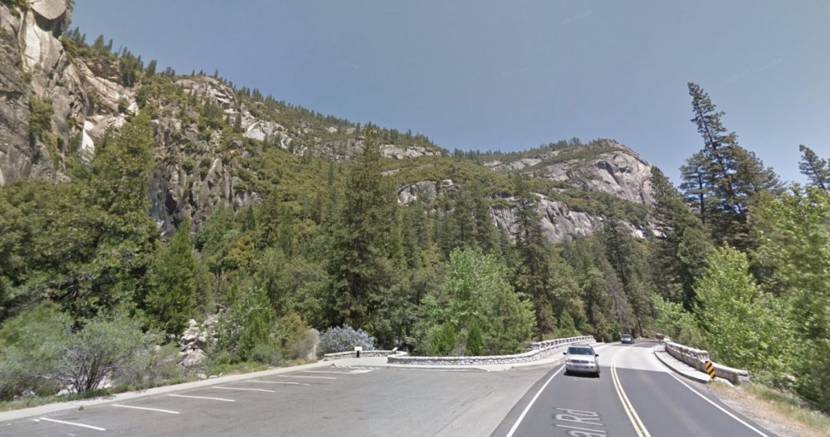
A Google Maps view of the steep terrain from Cascades Picnic Area before the fire
The gap between Highway 41 and Highway 140 is as much as two miles wide on the south and narrows to about one-half mile wide near Elephant Rock. The terrain is extremely steep and too dangerous to put firefighters into. As those familiar with the road know, it is a nearly vertical drop in places from Highway 41 down to the El Portal Road.
Bucket drops from helicopters have not had a significant enough effect to stop the spread to the north from Grouse Creek due to the extreme heat and dry vegetation, so removing the fuel by firing has been the safest and most effective tactic.
By firing from the top of the rim along Highway 41 above the Merced River, the fire will back down into the canyon. A backing fire is not an aggressive fire, as it is not rushing up the mountain, drying things out on the steep slopes above it. A slower-moving fire will allow crews to tie it in across the northern perimeter near Elephant Rock.
The firing is done at night when there are down-slope winds to draw the fire and the smoke down into the canyon. It is a very effective tactic to not only keep the firefighters out of danger, but to allow them to steer the fire in the direction they want it to go.
Two nights ago, firefighters took advantage of the moderate fire behavior to conduct firing operations along Highway 140 just north of the Arch Rock entrance to remove vegetation.
In the Glacier Point Road area west of Highway 41, Hot Shot crews have been working to cut line directly along the edge of the fire from both the north and the south. More firefighters then put in a progressive a hose lay along that line – carrying hose on their backs and connecting it as they go.
Once the hose lay is in, they can begin mop-up which is basically a search and destroy mission to find the hot spots and get the heat out of the fire’s edge. The focus is to keep the fire from spreading east up the drainages.
Mop-up continues around Yosemite West and along Highway 41 south to Wawona. All lines are holding well.
The southern and western perimeters of the fire are in patrol status, and suppression repair work is underway.
The Ferguson Fire started on Friday, July 13, at 8:30 p.m., near Savage Trading Post on the south side of the Merced River canyon along Highway 140. The cause remains under investigation.
The estimated date for full containment is Aug. 15.
Ten structures have been destroyed by the Ferguson Fire. Damage assessment teams have been able to get into some of the burn areas of the fire, and report that most of the 10 structures reported lost were in the Ned Gulch area on the north end of the fire. According to locals, these were historic mining operation structures that were being restored and used weekly for various types of outings and expeditions.
There have been 14 firefighter injuries reported, and numerous instances of heat exhaustion-type symptoms. There have been two fatalities on the fire; HFEO Braden Varney was killed in a dozer rollover accident on July 14, and Brian Hughes, Arrowhead Hotshot Captain, lost his life on July 29 when he was struck by a tree during a firing operation.
Yosemite National Park
Officials have announced that the closure of some portions of Yosemite National Park will be extended indefinitely. When the park does open these areas, limited visitor services will be available inside Yosemite Valley, including campgrounds, lodging, and food service operations.
Yosemite Valley has been closed since July 25 due to smoke impacts and for firefighting operations along El Portal Road and the Wawona Road.
The Mariposa Grove of Giant Sequoias and the Wawona Road (Highway 41) from the south entrance of Yosemite National Park to Tunnel View will remain closed until further notice.
The Big Oak Flat Road (Highway 120 West) to Crane Flat has been reopened. Tioga Road (Highway 120 East) from Crane Flat to Tioga Pass, remains open to all visitors and vehicles. All trails and campgrounds along Tioga Road, including the Tuolumne Meadows Campground remain open. All visitor services along Tioga Road, including the High Sierra Camps and visitor services near Tuolumne Meadows, remain open.
Residents of Yosemite Valley were allowed to return home on Wednesday. Yosemite Valley has been closed to the public since July 25, however Yosemite National Park remains open along Highway 120 which provides access to the Tuolumne Meadows Visitor Center, the Pacific Crest and John Muir trails.
Yosemite National Park is working closely with the Incident Management Team and continues to assess park conditions daily.
For updated 24-hour road and weather conditions for Yosemite National Park, please call 209-372-0200, press 1 and press 1 again. Updated information is also available on the park’s website at www.nps.gov/yose and on the Yosemite National Park Facebook page.
Air quality issues
For information on air quality specific to Mariposa County visit http://www.mariposacounty.org/index.aspx?NID=1434. For additional information on air quality you can visit the AirNow website or the air fire smoke page.
The San Joaquin Valley Air Pollution Control District has also warned that a health caution is in place and smoke impacts will continue until the fire is extinguished.
Wildfire smoke is a mixture of gases and fine, microscopic particles that can cause health problems including triggering asthma attacks, aggravating chronic heart and lung diseases, and increasing the risk of heart attack and stroke. Where conditions warrant, people with heart or lung disease should follow their doctors’ advice for dealing with episodes of particulate exposure. People with existing respiratory conditions, young children and elderly people are especially susceptible to the health effects from these pollutants. Anyone being exposed to poor air quality or wildfire smoke should move inside to an air-conditioned environment.
Residents can check the San Joaquin Valley Air Pollution Control District’s wildfire page at www.valleyair.org/wildfires for information about any current wildfires and whether they are impacting the Valley. The District’s Real-time Air Advisory Network (RAAN) provides localized air quality data from an extensive air-monitoring network which allows Valley residents to track PM at any Valley address by visiting myraan.com.
General Information
If community members see new fire activity, they are asked to call 911, not the fire information line.
As of July 21, there are fire restrictions in place on the Sierra National Forest. Please read and be informed before you use any type of fire in the forest.
The Incident Command Post for the Ferguson Fire is located at the Ahwahnee Hills Regional Park. Please be aware of heavy fire equipment moving through the area. There is also a base camp set up on the Stanislaus National Forest. Personnel at the fire camp at Badger Pass have been relocated to the ICP in Ahwahnee due to active fire in the area.
Cal Fire exited Unified Command as of 6 a.m., Thursday, July 26, because of reduced threats to state and private lands. Cal Fire remains committed to the Ferguson Incident as an assisting agency. California Interagency Incident Management Team 3, led by Incident Commander Mark von Tillow, has assumed management of the Ferguson Fire as of 6 a.m. on Friday, Aug. 3, transitioning in for California Team 4, which had be managing the fire since July 19.
For information about the fire please call 530-377-6221.
Stanislaus National Forest Supervisor Jason Kuiken has signed a forest order closing several Groveland Ranger District roads and trails impacted by the Ferguson Fire. This closure is based on the current and expected fire behavior and will be in effect until Sept. 30, or until replaced or rescinded. Click here for details and a map of the closure.
Be sure you are signed up to receive alerts when wildfire or other emergencies threaten.
- To sign up for the Mariposa Sheriff’s Office Emergency Alert System visit https://local.nixle.com/register.
- To register for the Madera County Sheriff’s Office Emergency Alert System visit mcalert.org.
Evacuations
New today: Evacuations were lifted for the community of Forest at 8 a.m. today.
Big Oak Flat Road opened at 8 a.m. to residents and employees only.
Foresta Road opened at 8 a.m. today
New yesterday: Residents of Yosemite Valley were allowed to return home as of 10 a.m. yesterday using the Highway 140 entrance only. The Valley is still closed to the public.
Mandatory evacuations remain in place for:
- Yosemite Valley – residents only.
The Red Cross Evacuation Center at New Life Christian Fellowship in Bootjack was closed at 2 p.m. yesterday.
Road Closures
- Summit Road
- Highway 140 is closed from the park gate east
- Highway 41 from the south gate of Yosemite to Wawona and Yosemite West is open to residents only
General information on returning to previously evacuated areas:
Mariposa County Sheriff’s Office will have a heavy presence in the area to ensure the security and safety of residents and businesses.
There will still be smoke in the respective areas as firefighters continue firefighting operations. If at any time you feel unsafe, please call 911.
For questions or concerns regarding power, please contact PG&E at 800-743-5000 or visit their website at www.pge.com.
The Mariposa County Health Department has health and safety information for residents returning to their homes on their website at http://www.mariposacounty.org/health or call 209-966-3689.
Mariposa County Health and Human Services will be available to assist residents with gaining additional services. Additional information regarding these and other services is available at www.mariposacountyrecovers.org.
SAFETY MESSAGE – The public is reminded to stay vigilant on current fire conditions. Please continue to adhere to road closures and any evacuation warnings. If you see electrical wires on the ground, stay clear and contact PG&E immediately. Trees and poles with deep charring, particularly if still smoking, should be considered hazardous. Please drive slowly and yield to emergency personnel in the area. As you re-enter your property and evaluate damage, be aware that hazardous conditions may exist, particularly if a residence or out-building has burned. Hazards may include asbestos, heavy metals, by-products of plastic combustion and various other chemicals. We encourage the public to remain prepared year-round for wildfires by visiting the www.readyforwildfire.org website. The best show of support is having your home and property “fire-ready.”
Cooperating Agencies on the Ferguson Fire include:
- Bureau of Land Management
- California Conservation Corps
- California Department of Corrections
- California Highway Patrol
- California Office of Emergency Services
- Cal Fire
- Caltrans
- Central Califonia Animal Disaster Team
- Hetch Hetchy Water & Power
- Madera County Sheriff
- Mariposa County Public Works
- Mariposa Public Works
- North Fork Rancheria of Mono Indian of California
- Pacific Gas and Electric
- Red Cross
- San Francisco Department of Emergency Management
- Sierra Tel
- Tuolumne County Sheriff
- Yosemite Mountain Ranch
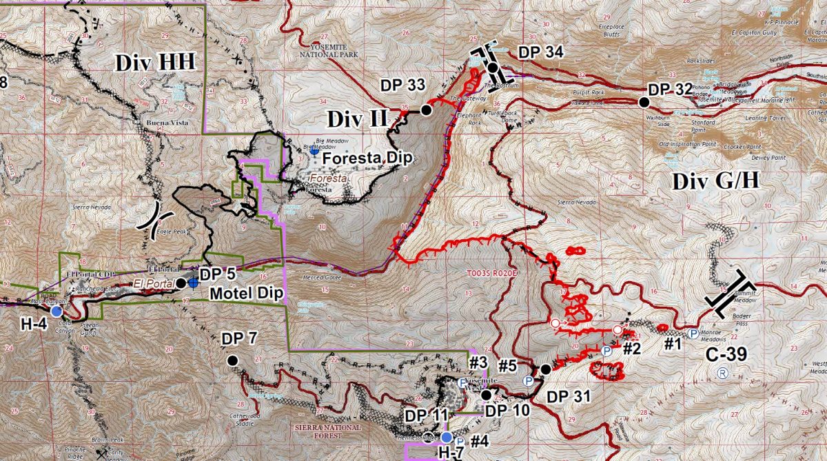
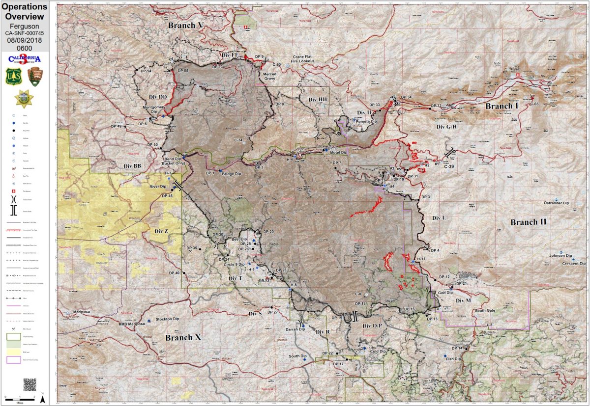
Once again, no new maps have been provided showing the day’s developments. These are the maps for the day shift today.