YOSEMITE – Thunderstorms came through the park starting July 1, and remained active through July 11, sparking several new fires. Yosemite National Park currently has nine lightning-caused fires.
These kinds of fires can take days or weeks to detect because vegetation has to dry out enough to create smoke or visible flames after the storm passes over. Additional fires may be discovered, as temperatures remain warm and fuels dry out.
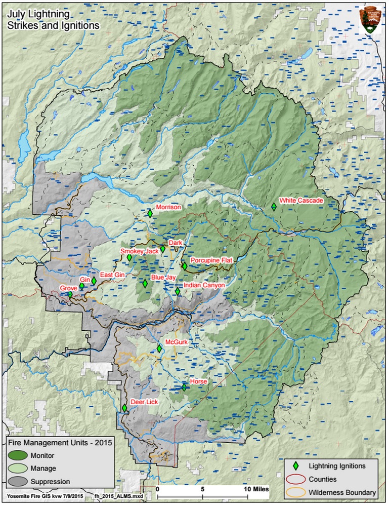
Most of these fires are small; single tree strikes that amount to less than a tenth of an acre. These fires are in the wilderness and are being monitored by either fire crews hiking into the fire areas or via air reconnaissance due to location, sparse fuels, and low growth potential. Yosemite and Point Reyes fire crews are monitoring all fires.
Fires in Yosemite:
Blue Jay (37 47.204 x 119 39.183 – Mariposa Co., 8,500’ el., 7/7). There is no smoke showing from this fire.
Dark (37 50.575 x 119 37.153 – Mariposa Co., 8,200’ el., 7/ 9). This lightning caused fire is along the Yosemite Creek Campground Road. Two red fir trees were struck and the surface fuels were ignited. It is at .1 acre and is being monitored.
Morrison (37 54.0 x 119 38.8 – Tuolumne Co., 8,100’ el., 7/9). This fire is east of White Wolf and in an area of many past lightning fires. It is at .1 acre, with low potential for growth.
Horse (37 37.3 x 119 34.1 – Mariposa Co., 8,500’ el., 7/9). This high elevation fire is one single tree struck and smoking and is east of Ostrander Lake. It is .1 acre, is surrounded by granite and has low potential for growth.
Clark (37 41.0 x 119 29.6 – Mariposa Co., 7,500’ el., 7/9). This is west of Clark Peak. A single tree was seen smoking and it is at .1 ac., with low growth potential.
Indian Canyon (37 47.532 x 119 35.148 – Mariposa Co. at 7,200’ el., 7/ 3). This fire is between the Tioga Rd and the Yosemite Valley. It is .5 acre in size, and is smoldering and creeping, with a low rate of spread. It is an area of few recent fires.
McGurk (37 40.969 x 119 37.232 – Mariposa Co. at 7,800’ el., July 2). This fire is within the McGurk Meadow, near a trail to Dewey Point from Glacier Point Road. It is at .2 acre and has low potential for spread.
Porcupine Flat (37 48.962 x 119 34.416 – Mariposa Co., at 8,000’, July 3). The top of a single green red fir tree was struck by lightning. There is no ground fire, but smoke may be seen from the Tioga Road. It has low potential for growth.
White Cascade (37 54.926 x 119 23.780 – Tuolumne Co, at 9,000’ el., July 3). This is a remote fire near Glen Aulin High Sierra camp and west of Tuolumne Meadows. It poses no threat to trails and has a low spread potential.
Fires declared out:
Grove (37 45.968 X 119 48.261 – Mariposa Co.) This fire has been declared out July 9.
Smokey Jack (37 49.693 x 119 41.189 – Tuolumne Co.) This fire has been declared out July 9.
Others: Gin and East Gin were put out.
As with all fires, park officials consider staff and visitor safety to be of paramount importance. Each fire, regardless of size, is assessed for the appropriate course of action.
All visitors are urged to use established campgrounds for fires. In all campfires, when departing, please be sure fires are completely out.
No building, maintaining, attending or using a fire, campfire, or cooking fire (including charcoal fires) within Yosemite National Park including designated Wilderness and at High Sierra Camps below 6,000 feet in elevation. Portable stoves using pressurized gas, liquid fuel, or propane are permitted as are alcohol stoves (with and without a shutoff valve) including alcohol tablet/cube stoves. “Sierra” (twig) stoves are not permitted.
No smoking below 6,000 feet, except within an enclosed vehicle, a building in which smoking is allowed, a campground or picnic area where wood and charcoal fires are allowed or in a designated smoking area.
Campfires and cooking fires may still be used in designated campgrounds in developed portions of the park in accordance with park regulations.
For more information on where campfires are allowed, click here.
• Yosemite Web: http://www.nps.gov/yose/blogs/fireinfo.htm.
• Air Quality – three sites are listed: ; http://smoke.airfire.org/monitoringReport/#/?monitors=060431001&monitors=NPS.YOS1003.Ebam&monitors=Yosemite.NP.1&date=LATEST&productType=plotTable ; http://www.californiasmokeinfo.blogspot.com/ & http://viewer.smoke.airfire.org/run/standard/CANSAC-2km/2015062200/