NORTH FORK – Firefighters made good progress on the Willow Fire today, strengthening lines, finishing hose lays, doing mop-up where possible, and clearing snags.
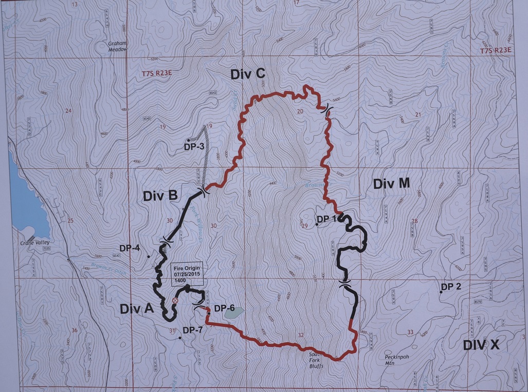
Though there is no updated acreage on the fire as of this writing, the Incident Commander told the crowd at a packed Town Hall meeting this evening in North Fork, that he hopes for 30 percent containment by the end of the day. The last estimated acreage after last night’s flyover was 1,739 acres.
One of the areas of most concern for both the public and fire officials is the southern perimeter, running from Willow Creek, up the South Fork Bluffs to the top of Peckinpah Mountain.
 Many residents watched with concern late yesterday as the fire crossed the retardant line and began burning farther to the south, outside the perimeter.
With firefighters unable to engage on much of that line yesterday due to safety concerns, Incident Commander David Cooper explained that the events of late yesterday on the southern perimeter were actually advantageous to planners and firefighters.
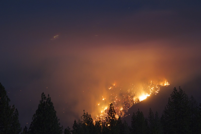
“That area was a huge bowl, very steep and full of brush and dead material from the 2001 fire, with lots of old snags,” says Cooper. “That’s pretty much what we saw burning last night. That was the material that was making it really difficult for us to get a good line on Division Z (see map below).”
Cooper says that the burnout late yesterday has allowed crews to go in and put in direct line, which is much safer for firefighters.
Direct line is where crews construct fireline close to the edge of the fire, and the fuel in between is either burned out, or the fire is allowed to burn to the fireline. Direct attack is generally used when a fire is burning in light fuels or those with high moisture content, or when there is little wind. The major advantage of direct attack is firefighter safety, allowing them to escape back into the burned out area as a safety zone.
Indirect line is where a fireline is built some distance from the edge of the fire, and the remaining fuel is backfired. Indirect attack allows firefighters to take advantage of natural and man-made barriers, and lets them choose when to accomplish the backfire.
 “That portion was too dangerous, but we can get to it now and can actually do something with it,” said Cooper, who also explains how the fire got past the large retardant line.
“There are a lot of big, old logs that have been laying there on the ground for the past 14 years,” he said, referring back to the 2001 fire. “It works really well putting water or retardant on that during the daytime, but as soon as nighttime comes, the fire just runs along under those big logs where the retardant didn’t reach.”
The fire then pops up on the other side and the dead trees and snags start torching, just the way they did late yesterday afternoon. The ridge the fire burned out to, consuming about 70 acres in its wake, is much more conducive to building fireline, and keeping crews safe.
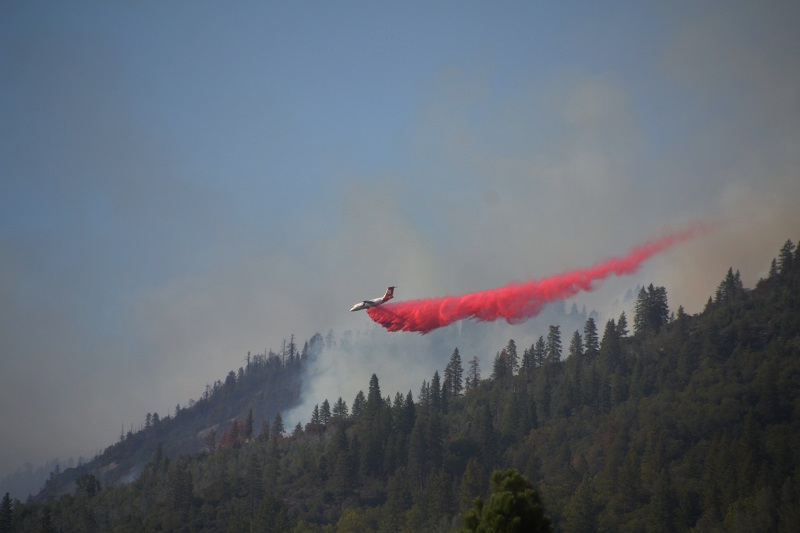
After the inversion lifted today, air resources moved in to support ground crews, and good progress was made on that very steep perimeter.
 There was also lots of activity on the north end of the fire in Division C, as crews and dozers worked to tie in lines at 7 Rock near Sand Creek. There is still good potential for spot fires and rolling, burning logs in this steep section, but planners feel they made good work of today’s challenges.
Divisions A and B were fairly quiet today as far as active fire behavior, and crews have the lines on top of Peckinpah Mountain well handled at this time.
Division C was a new addition to the map yesterday, and Cooper explains that when suppression first starts, they lay out Divisions A and B, then Division M (which is in the middle of the alphabet), and then Division Z. As the perimeter expands, and each Division Boss becomes responsible for a larger and larger area, they begin to break the fireline into smaller sections, filling in the letters in between, keeping the areas of responsibility at manageable levels, and assigning a new set of resources to that new Division.
As the fire moves into the old burn scar from the 2001 fire, resistance to control increases due to heavy brush and dead woody materials.
Temperatures are expected to continue to rise over the next few days, and the management team is warning firefighters to be prepared for active fire behavior throughout the night, with low humidity recovery. Localized down canyon winds in the Willow Creek drainage may push the fire at night.
Anticipated monsoonal moisture may produce dry thunderstorms beginning Thursday, and turning wet Friday and Saturday
There are currently 1,487 personnel assigned to the incident with 71 engines, 21 hand crews, 23 water tenders, 16 dozers, 8 helicopters, and 5 air tankers available.
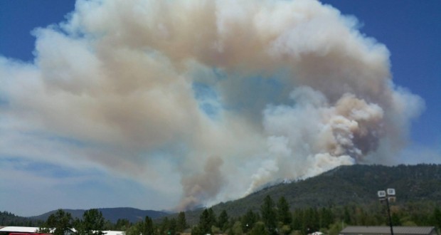
The Willow Fire started on Saturday, July 25, at about 2 p.m., and is burning just east of the south shore of Bass Lake, and about three miles north of North Fork, Calif.
(Black lines in the map are completed firelines, red lines indicate uncontrolled fire edge, xxxx’s are dozer lines).