YOSEMITE — With smoke from the Empire Fire affecting many iconic views in Yosemite National Park, many may wonder why they are allowed to burn.
Recent weather events have sparked at least seven lightning fires in the park — most less than one-quarter acre — and those fires are all part of the natural ecology of the area, as was explained in today’s Yosemite Daily Report:
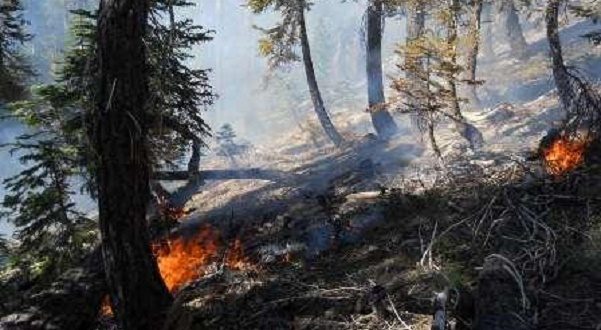
Fire and smoke are as much a part of the Yosemite ecosystem as water and ice.
Every year, thousands of lightning strikes occur within park boundaries, igniting vegetation made tinder-dry by Yosemite’s long, hot summers. Inevitably, some of these strikes cause fires, which in turn emit smoke.
Yosemite’s fire managers strive to protect the quality and clarity of the air that park visitors breathe. Fire and smoke cannot be eliminated in Yosemite, only managed to minimize health impacts due to smoke while preserving the fragile ecology that keeps vegetation sparse enough to prevent much larger fires.
More than 30 years of fire ecology have taught fire managers that suppressing all fires only delays the inevitable, making the results more intense than they otherwise would have been.
Just as dam operators must let some water spill through their dams in order to prevent floods, fire managers must let some fire and smoke occur to keep the larger conflagrations at bay, especially in the mid-elevation mixed confer forests where a “flood” of accumulated biomass threatens to be released by catastrophic fire.
Overall, Yosemite’s fire management program minimizes the health impacts from the region’s inevitable fires while maximizing the resource benefits that result from those fires.
Current fires in Yosemite:
Empire
Discovered: 8/1/17
Location: N 37° 38.673′ x W 119° 37.096′ at roughly 7300 feet elevation
Size: 750 acres
Cause: Lightning
Spread Potential: Moderate
Fuels: Red Fir Strategy: Monitor
County: Mariposa
Knob 91
Discovered: 8/4/17
Location: Location: N 37° 52.185′ x W 119° 35.217′, 2 miles North East of Lukens Lake on a ridgetop
Size: Less than one-quarter acre
Cause: Lightning
Spread Potential: Low
Fuels: Timber litter
Strategy: Monitor
County: Mariposa
Yosemite Creek
Discovered: 8/3/17
Location: N 37° 50.414′ x W 119° 38.088′ at roughly 7,970 feet elevation
Size: less than one-quarter acre
Cause: Lightning
Spread Potential: Moderate
Fuels: Red fir
Strategy: Monitor
County: Mariposa
Blue
Discovered: 8/2/17
Location: In the Blue Jay Creek drainage at roughly 8,715 feet elevation
Size: less than one-quarter acre
Cause: Lightning
Spread Potential: Low
Fuels: Mountain hemlock/Jeffrey Pine
Strategy: Monitor
County: Tuolumne
Jay
Discovered: 8/2/17
Location: In the Blue Jay Creek drainage at roughly 8,653 feet elevation
Size: less than one-quarter acre
Cause: Lightning
Spread Potential: Low
Fuels: Mountain Hemlock/Jeffrey Pine
Strategy: Monitor
County: Tuolumne
Porcupine
Discovered: 8/2/17
Location: N 37° 49.336′ x W 119° 34.720′ at roughly 8,154 feet elevation just off Tioga road near Yosemite Creek Campground road
Size: less than one-quarter acre
Cause: Lightning
Spread Potential: Low
Fuels: Lodgepole/Red Fire
Strategy: Monitor
County: Mariposa
Starr King
Discovered: 8/2/17
Location: N 37° 42.965′ x W 119° 29.588′ at roughly 7,800 feet elevation
Size: less than one-quarter acre
Cause: Lightning
Spread Potential: Moderate
Fuels: Red Fire/ Lodgepole
Strategy: Monitor, no threat to Little Yosemite Valley
County: Mariposa
For additional Information:
Fire Information: Yose_Fire_Info@nps.gov
Yosemite National Park Fire Information website: http://www.nps.gov/yose/blogs/fireinfo.htm
Facebook: http://www.facebook.com/pages/Yosemite-Wildland-Fire/124632964255395
Twitter: https://twitter.com/YosemiteFire
Air Quality: https://www.nps.gov/yose/learn/nature/aqmonitoring.htm
(Source: YOSE Daily Report M. Roubal 8-11-17)