CENTRAL SIERRA — Here is an update on the four major fires burning in our area as of this morning.
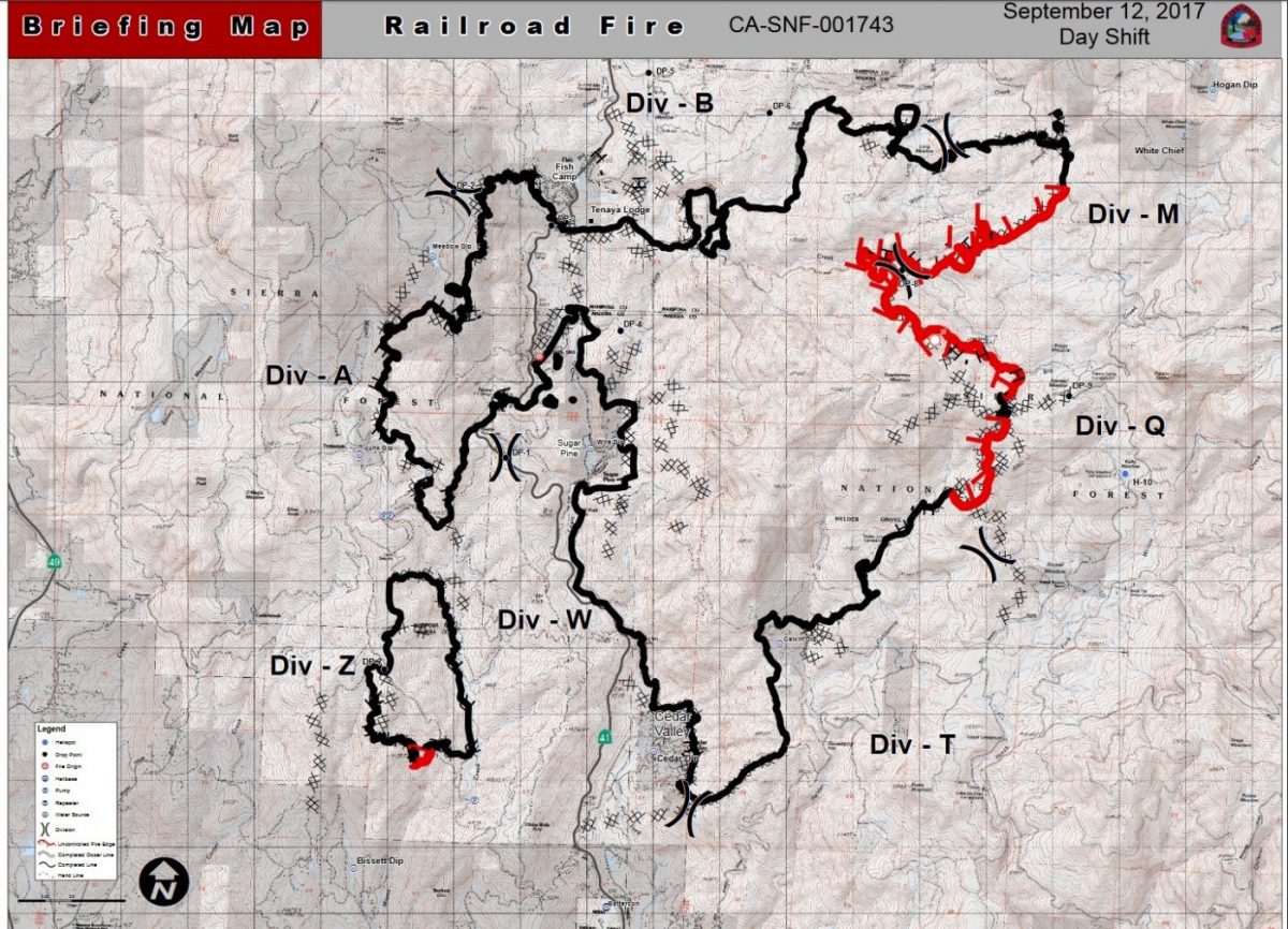
The Railroad Fire has not grown over the past 24 hours, and is holding at 12,407 acres. It is now 80 percent contained.
There were no crews on the fireline last night. Thunderstorms brought about a quarter inch of rain over the fire area overnight. Line construction is complete, and today crews will continue with mop-up operations to extinguish hot spots near the perimeter.
Crews will also continue with fireline suppression repair, repairing or improving land damaged during fire suppression and line construction activity.
Of current total area burned, 11,464 acres were on the Sierra National Forest, and 943 acres were private land.
The Sierra National Forest has issued a Forest Closure Order for the area impacted by the Railroad Fire.
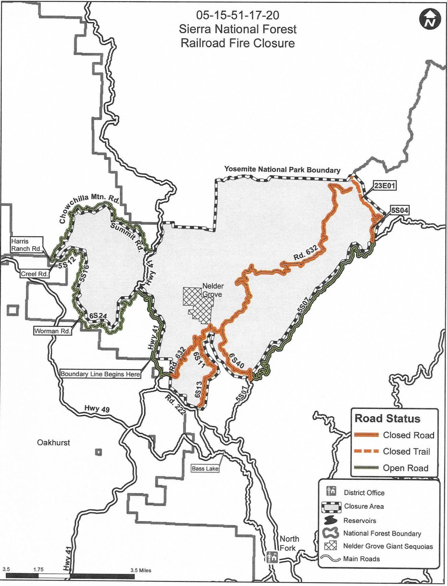 “Closure of the fire area is necessary to help ensure that no one is injured within or near the active fire perimeter,” said Forest Officials in a statement released yesterday. “All National Forest System roads and trails, within the active fire perimeter will be closed due to fire suppression and rehab activities that create a hazard to the public which includes the falling of hazard trees that were weakened by the fire and the construction and maintenance of fuel breaks.”
This closure will remain in effect until the fire is declared out. (Click map to enlarge).
There have been 17 structures lost to the Railroad Fire, and 6 injuries to firefighters.
All Red Cross and Central California Animal Disaster Team shelters have been closed. All evacuations have been lifted.
The cause of the fire remains under investigation.
(See Railroad Fire map at the bottom of the page).
The Mission Fire in North Fork is holding at 1,035 acres and is now 86 percent contained. Firefighters continue their work to mop up and strengthen firelines. There was rain overnight across the fire area.
All evacuations and road closures have been lifted.
The cause of the fire remains under investigation.
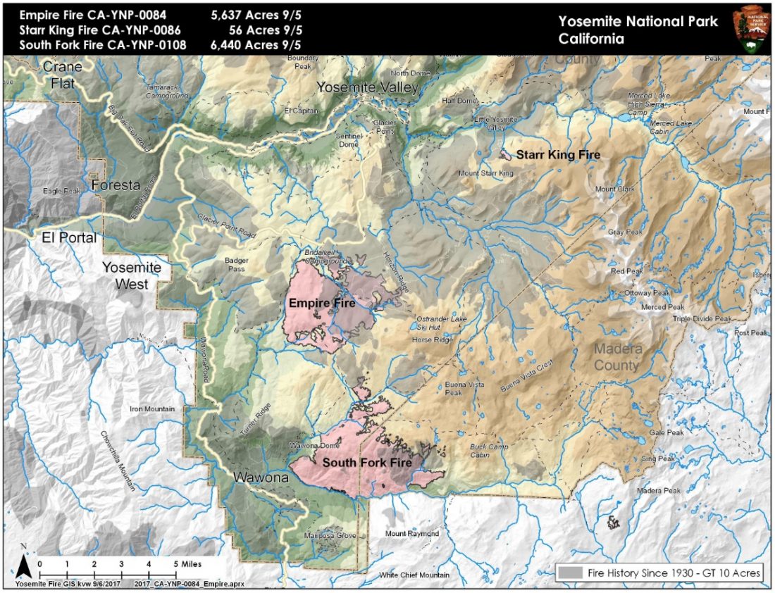
The Empire Fire in Yosemite National Park is now 6,000 acres and 55 percent contained.
Fire activity increased in the last few days due to a strategic burning operation near Glacier Point Road between Ostrander Trailhead and Mono Meadow Trailhead. This activity will continue today to tie the northern flank of the fire to Glacier Point Road.
Glacier Point Road remains closed until further notice due to fire operations.
Showers and thunderstorms are possible this afternoon, bringing gusty and erratic winds.
Fire crews are implementing a perimeter control strategy for the north, west, and southern flanks of the fire to protect Bridalveil Campground, Yosemite Ski and Snowboard Area, Yosemite West subdivision, Wawona Road (Highway 41), and Glacier Point road. Today crews continue the strategic burning operations which will minimize high fire behavior along Glacier Point Road.
The west and south flanks of the fire are contained, holding, and will continue to be monitored by aircraft and fire personnel. Areas of new smoke may be seen as the fire cleans up areas of unburned fuel interior.
The east flank is being allowed to move towards the Illilouette basin, say park officials, to continue to enhance forest resiliency in a fire adapted ecosystem.
“Yosemite National Park has managed fire in this wilderness area for decades. This area is very steep and rugged, with numerous natural barriers and minimal values at risk.”
Smoke is expected to be moderate throughout the Yosemite area today, except for Wawona, as the Railroad Fire activity winds down. Winds from a more southerly direction could bring light smoldering smoke north into Yosemite from the Railroad Fire, combining with smoke from South Fork and Empire Fires. These impacts are expected to be moderate and mostly transient; dense smoke not expected.
Dispersion will decrease slightly today and tomorrow, with possible thunderstorms this afternoon.
The following trail and area closures are in place until further notice:
• Glacier Point Road
• Bridalveil Campground
• Ostrander Trail
• Bridalveil Trail
• Alder Creek Trail
• Mono Meadow Trail
• Turner Meadow Trail
All closed trailheads and junctions will be posted with a trail closure order and map.
The South Fork Fire near Wawona is now 6,840 acres and is 47 percent contained.
The fire remains quiet near the community of Wawona on the west and south flank of the fire. Sections of the north flank and the entire east flank are continuing to burn in the wilderness.
Showers and thunderstorms are possible this afternoon, with a slight increase in temperatures. Gusty and erratic winds are possible with any thunderstorm that develops.
There may be some burning well interior and visible smoke with increased winds due to the storms. The fire will be monitored by aircraft and fire lookouts.
As fire burns into the high country wilderness it will burn actively through pockets of dense vegetation but will then slow down as it progresses into sparse vegetation and natural granite barriers limiting smoke production, say park officials. “This high country wilderness area has minimal values at risk.”
The following trail and area closures are in place until further notice:
•The Swinging Bridge Trail on both the north and south sides of the South Fork of the Merced River.
•The Chilnualna Falls Trail from Wawona Trailhead to the top of Chilnualna Falls.
•The two mile connecting trail heading north from the top of Chilnualna Falls to the intersection of the Buena Vista Trail.
•The Chilnualna Creek Trail from the top of Chilnualna Falls east to the intersection of the Buena Vista and Buck Camp trails (Just east of Johnson Lake).
•Turner Meadow Trail
•Turner Meadow intersection east to Buena Vista trail
•Off-trail areas in the vicinity of the South Fork Fire Area, including the swimming holes north of Chilnualna Creek.
• All climbing routes on and around Wawona Dome are closed.