A School, A House, A Home —
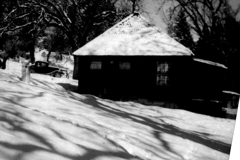
This is the photo of the first house that Grover and Dorothy Whitener bought. The building was located along the South Fork of Willow Creek just east of the town of North Fork, and was formerly a schoolhouse before it became a residence.
The Mystery — What was the name of that school?
If you know anything about the old school in South Fork, please make a comment below or send an email to northforkhistorygroup@gmail.com.
The North Fork History Group
Followup on the History Mystery #57:
E Clampus Vitus 41-49 wants to thank those who responded to our History Mystery on the real location of the Zebra Mine. We are in contact with a lady who grew up on the property where the mine is located and she will eventually show us that location.
Unfortunately, she has had a medical issue and this will have to wait until she is back on her feet again. According to her, the spot that we thought may have been an air shaft to the Zebra is actually another long forgotten mine. The interesting thing is why two mining maps show the location of the Zebra Mine to be out in the O’Neals area – that’s another History Mystery begging to be answered.
Steve Varner
Historian
ECV Chapter 41-49
Response from Bob Costa on History Mystery #57:
This Mystery has been hanging around for quite a while, actually since October of 2017. The solution will probably explain why it’s been so elusive.
There was initially some suspicion that it could be the old Zebra Mine but for years the location of the Zebra Mine has had folks guessing about just where it is hiding. Some old timers say it’s up behind O’Neal’s and others say it’s over near Rd 207. They can’t both be right, right? Wrong!
History Mystery #57, the pictured hole in the ground, filled with water is registered with the BLM as The Zebra Mine and its coordinates place it about a half mile northwest of O’Neal’s on old Forest Rd 8080. But then what’s all that business about it being near road Rd 207? It appears that there was another Zebra Mine. This mine, off Road 207, is also registered with the BLM but as Zebra #2. The coordinates of this mine put it west of Road 207 near the summit of Red Top Mountain.
For all the History Mysteries, visit https://sierranewsonline.com/category/mountain-living/history/

