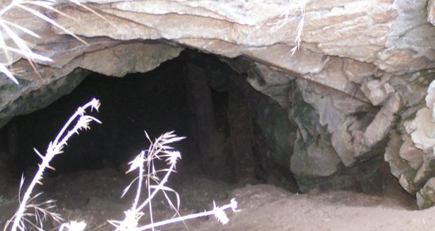
 In the Blackhawk Lodge area, there is what appears to be part of a mine or mine airshaft complete with wood timbers.
The tunnel is slanted at a 45-degree angle and is flooded with water about 20 feet from the surface.
E Clampus Vitus (ECV) 41-49 has been working on a project to locate the old Zebra Mine, and several mining publications list that mine as being off Road 8080 up behind O’Neals.
 However, several old timers say the mine was off what is now Road 207, and other accounts depicting the stage route identify the Zebra Ranch stage stop northwest of the Blackhawk Lodge, so named because of the Zebra Mine nearby.
Is this site near the Blackhawk Lodge the real location of the Zebra Mine, or the mine airshaft, or another lost and unnamed mine, or possibly the remains of an old well? We would appreciate any insight into this mystery.
Please be aware that mine shafts and tunnels are a hazardous place and people should not try to enter these under any circumstances. These are steep and often full of water – look at a distance but do not enter!
Steve Varner
Grub Gulch Chapter 41-49, E Clampus Vitus
Response from Bob Costa on History Mystery #57:
This Mystery has been hanging around for quite a while, actually since October of 2017. The solution will probably explain why it’s been so elusive.
There was initially some suspicion that it could be the old Zebra Mine but for years the location of the Zebra Mine has had folks guessing about just where it is hiding. Some old timers say it’s up behind O’Neal’s and others say it’s over near Rd 207. They can’t both be right, right? Wrong!
History Mystery #57, the pictured hole in the ground, filled with water is registered with the BLM as The Zebra Mine and its coordinates place it about a half mile northwest of O’Neal’s on old Forest Rd 8080. But then what’s all that business about it being near road Rd 207? It appears that there was another Zebra Mine. This mine, off Road 207, is also registered with the BLM but as Zebra #2. The coordinates of this mine put it west of Road 207 near the summit of Red Top Mountain.
Follow-up on History Mystery #56
 In a 1983 interview of Alexander McGilvray (in the book “As We Were Told” put out by the Coarsegold Historical Society) he says “… the Hillside Quarry a mile south of the Knowles Quarry.” (page 184).
Connie Popelish