YOSEMITE — Wawona residents evacuated from their homes on Saturday can only watch and wait for a change in the erratic weather that has increased activity on the west flank of the South Fork Fire.
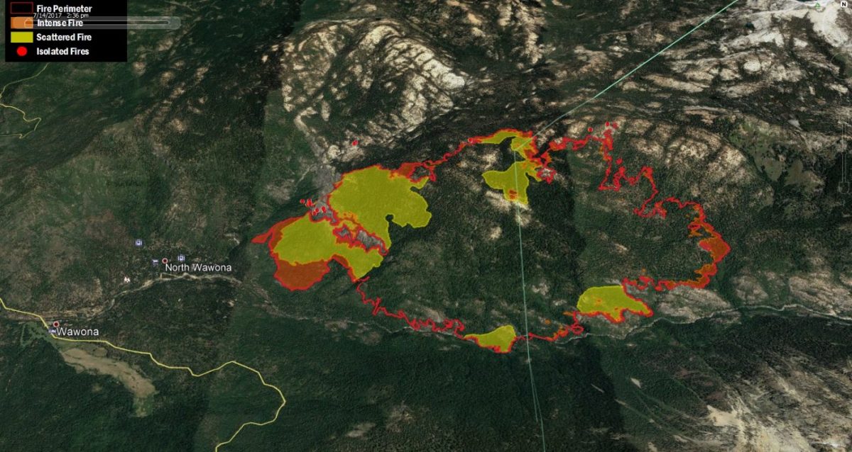
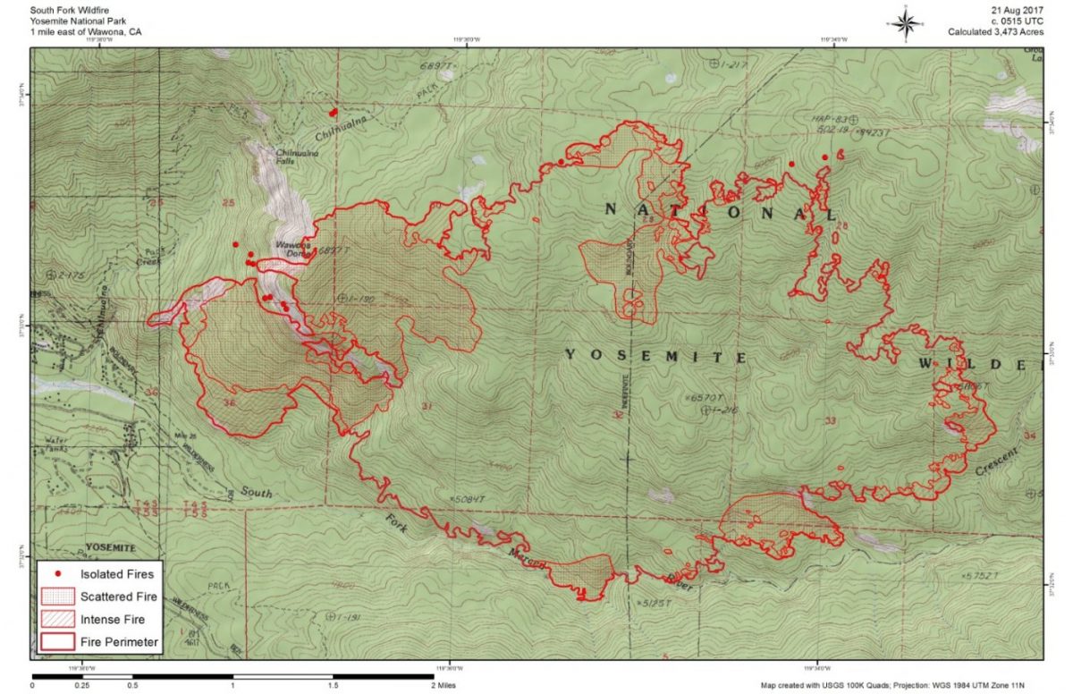
The fire is now estimated at 3,473 acres with 10 percent containment.
As the threat to the community of Wawona has grown with the daily thunderstorms pushing the fire west, additional resources have been requested. There are currently 758 personnel assigned to the incident.
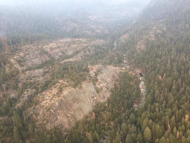
Steep rocky terrain on South Fork of the Merced River – photo NPS
Crews made significant progress yesterday building and strengthening line on the west side of the fire above Wawona. Contingency lines were also established to the northwest leading to Turner Ridge.
Firefighters now have access to the South Fork and have been inserted to extinguish spot fires that have been occurring the past few days. They are working in steep and inaccessible terrain with heavy fuel loads.
The west flank of the fire is approximately 1/4 mile east of Wawona. The fire continues to pose a threat to the community, along with the Mariposa Grove of Giant Sequoias.
Today crews will continue burning operations above Wawona from the fireline to the South Fork of the Merced River. A combination of firing operations, air support, and direct line construction will continue.
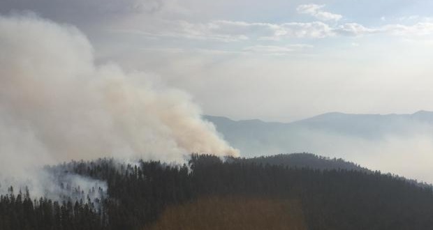
Aircraft are assisting ground crews when conditions allow, though morning hours are very smoky, keeping aircraft grounded until about mid-day.
The strategic objectives remain the same: utilize air and ground resources to hold the western and southern flanks while monitoring the northern and eastern edges.
Thunderstorm activity is expected to cause erratic winds over the fire area through mid-week. Gusty, erratic winds associated with thunderstorms could cause problematic fire activity on the west flank, should they materialize, and affect the firing operations.
Crews continue to use spike camps in an effort to utilize as much daylight as possible.
The Incident Command Post is located at the Yosemite Ski & Snowboard Area (Badger Pass). Firefighters are being “housed” there or in the Bridalveil Campground, which is closed to the public.
Firefighters are staged throughout the community of Wawona for structure protection. No structures have been damaged or destroyed. Law enforcement, rangers and security personnel are patrolling, and 24/7 roadblocks have been set up to secure and protect the evacuated area.
Some 200 guests were evacuated from the Big Trees Lodge (formerly known as the Wawona Hotel) on Saturday morning.
A Red Cross Evacuation Center has been set up at the Tenaya Lodge, and the Central California Animal Disaster Team has a small animal emergency shelter in Fish Camp at the old volunteer fire station, 7724 Summit Road. For information on the animal shelter, please text CCADT at 559-433-9663. Texting is preferred since cell reception can be a problem in the area.
There is a live information phone number and email for the South Fork Fire. The phone will be answered from 8 a.m. to 8 p.m. daily at 209-379-5322, or email SouthForkFireinfo@gmail.com.
The following areas are closed until further notice:
- The Swinging Bridge Trail on both the north and south sides of the South Fork of the Merced River.
- The Chilnualna Falls Trail from Wawona Trailhead to the top of Chilnualna Falls.
- The two mile connecting trail heading north from the top of Chilnualna Falls to the intersection of the Buena Vista Trail.
- The Chilnualna Creek Trail from the top of Chilnualna Falls east to the intersection of the Buena Vista and Buck Camp trails (Just east of Johnson Lake).
- Off-trail areas in the vicinity are closed (i.e. all areas within the shaded circle on the map below).
- All climbing routes on and around Wawona Dome are closed.
- Bridalveil Creek Campground closed on Wednesday morning.
- Wawona trail (mule) rides are not operating.
- Big Trees Golf Course is closed.
- The Badger Pass-Glacier Point shuttle will not operate until further notice as the incident command post is occupying the Yosemite Ski and Snowboard Area facility and parking lot.
- The Glacier Point Road will will remain open to the public however it will close periodically between 10 a.m. and 5 p.m. each day when parking at Glacier Point fills to capacity (and will reopen when sufficient space is available). Traffic delays should be expected.
- A voluntary ban on wood fires is in place in Yosemite Valley to reduce smoke. A mandatory ban may be instituted in the days to come.
The cause of the fire is under investigation.
The estimated date of containment is Sunday, Sept. 3.
To read about Saturday night’s community meeting at the Tenaya Loge, click here.
For additional information:
- Rapid Notify is a community alert system for rapid event notifications. Register by visiting www.alert.rapid notify.com
- Nixle is a public-safety notification system. Sign up for emergency alerts by texting 95389 to 888-777 or visit their website at www.nixle.com
- Fire Information: Yose_Fire_Info@nps.gov
- Yosemite National Park Fire Information website: http://www.nps.gov/yose/blogs/fireinfo.htm
- Facebook, search: Yosemite Fire and Aviation
- Twitter, search @YosemiteFire : http://www.twitter.com/YosemiteFire
Air quality links for Yosemite National Park:
https://app.airsis.com/USFS/UnitMap
https://www.nps.gov/yose/learn/nature/aqmonitoring.htm
Click here for a perimeter map.
Click here for interactive map.