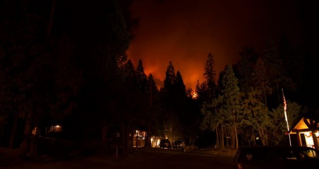
YOSEMITE — After increased fire activity on the west flank of the South Fork Fire forced residents of Wawona from their homes yesterday morning, they gathered at the Tenaya Lodge last night to hear from fire officials about the current situation.
Incident Commander Deron Mills assured everyone that the decision to evacuate was not taken lightly.
“We struggled with this decision and apologize that there wasn’t more time,” said Mills. “It’s not only the fire threat; we need room to operate large equipment and conduct air support. About 95 percent of our resources are focused on Wawona, and protection of the community is our number one priority.”
Law Enforcement Ranger Chad Andrews said public safety was foremost in their decision.
“We have a lot of staff living in Wawona, and this is personal to all of us,” he said, thanking the community for being prepared and for understanding. He also sought to assuage fears about the security of unoccupied homes.
“We have fire trucks parked in driveways and security patrols, rangers, and roadblocks that are manned 24/7. There will be no random people driving in. Your homes are secure.”
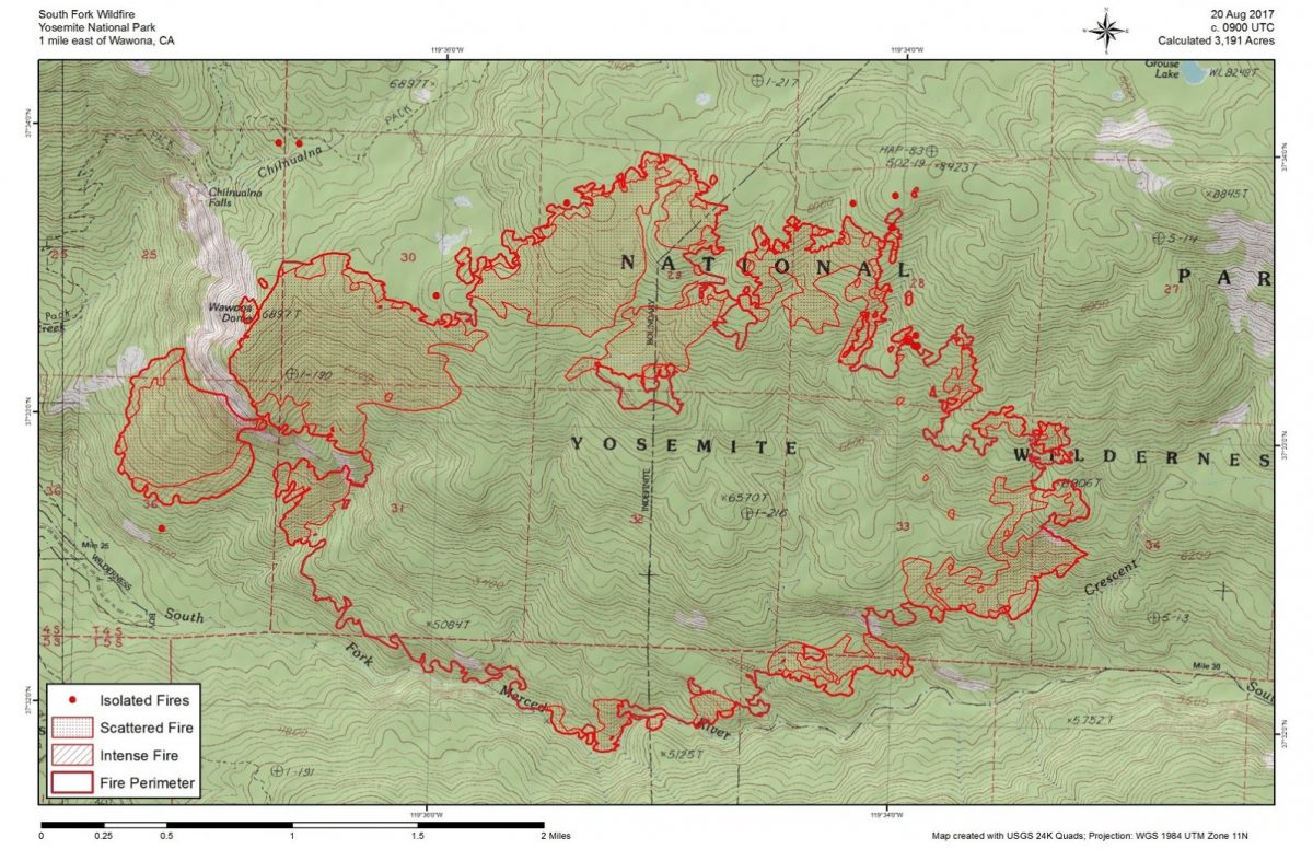
As of this morning, the South Fork Fire is estimated at 3,191 acres with 10 percent containment.
No structures have been damaged or destroyed.
There are currently 522 personnel assigned to the incident, but after the increase in fire activity on the west flank and southern perimeter, the Incident Commander says they have more resources on order and will be nearly doubling the size of the operation.
Thunderstorm activity near the fire is creating high, gusty winds and significant down drafts, and that pattern is expected to continue for the next few days. Erratic winds blowing back to the west is what sparked the spot fire outside the containment lines on Friday night and prompted officials to make the difficult decision to evacuate.
Operations Section Chief Jeff Hinson said fireline has been constructed from the Swinging Bridge up toward Wawona Dome, and that line has hose plumbed in and ready to go.
Crews have also been focused on the southern perimeter which runs along the South Fork of the Merced River. Several spot fires have started across the line to the south, and with the very steep terrain and dense brush, firefighters have rappelled from helicopters to handle those fires, as hiking in has been tried and is not possible.
Spike camps are being utilized as a way for firefighters to use as many of the daylight hours as possible.
The fire has remained active along the western and southern flanks following yesterday’s thunderstorms. Crews continued to strengthen contingency lines located east of Wawona. Heavy inversions cause aircraft to be grounded until late afternoon. When these inversions lift, fire activity increases.
Fire officials have asked for and obtained permission from the park superintendent to use dozers and chainsaws for line construction on the west flank, even though it is a wilderness area. Burn-out operations will be conducted in that very steep, brushy area as conditions allow.
Though fire activity has increased in the south and west, Hinson says most of the interior is burned out and smouldering.
Due to the dense smoke, aircraft were only able to operate from about 1 to 3 p.m. yesterday, and then from about 5:30 to 8 p.m.
The Incident Command Post is located at the Yosemite Ski & Snowboard Area (Badger Pass). Firefighters are being “housed” there or in the Bridalveil Campground, which is closed to the public.
Some 200 guests were evacuated from the Big Trees Lodge (formerly known as the Wawona Hotel) on Saturday morning.
A Red Cross Evacuation Center has been set up at the Tenaya Lodge, and the Central California Animal Disaster Team has a small animal emergency shelter in Fish Camp at the old volunteer fire station, 7724 Summit Road. For information on the animal shelter, please text CCADT at 559-433-9663. Texting is preferred since cell reception can be a problem in the area.
Though all eyes are focused on Wawona, Jamie Richards, Yosemite National Park Ranger and spokesperson, assures everyone that the park is still open and welcoming visitors.
“We are keeping as many visitor services open as possible, including the Wawona store and gas station,” says Richards. “Highway 41 is open to the Valley and we invite guests to come and enjoy the park.”
There is a new live information phone number and email for the South Fork Fire. The phone will be answered from 8 a.m. to 8 p.m. daily at 209-379-5322, or email SouthForkFireinfo@gmail.com.
In order to maintain the safety of park visitors and allow fire management operations to continue unimpeded, the Superintendent of Yosemite National Park is designating the following area as closed until further notice is given:
- The Swinging Bridge Trail on both the north and south sides of the South Fork of the Merced River.
- The Chilnualna Falls Trail from Wawona Trailhead to the top of Chilnualna Falls.
- The two mile connecting trail heading north from the top of Chilnualna Falls to the intersection of the Buena Vista Trail.
- The Chilnualna Creek Trail from the top of Chilnualna Falls east to the intersection of the Buena Vista and Buck Camp trails (Just east of Johnson Lake).
- Off-trail areas in the vicinity are closed (i.e. all areas within the shaded circle on the map below).
- All climbing routes on and around Wawona Dome are closed.
- Bridalveil Creek Campground closed on Wednesday morning.
- Wawona trail (mule) rides are not operating.
- Big Trees Golf Course is closed.
- The Badger Pass-Glacier Point shuttle will not operate until further notice as the incident command post is occupying the Yosemite Ski and Snowboard Area facility and parking lot.
- The Glacier Point Road will will remain open to the public however it will close periodically between 10 a.m. and 5 p.m. each day when parking at Glacier Point fills to capacity (and will reopen when sufficient space is available). Traffic delays should be expected.
- A voluntary ban on wood fires is in place in Yosemite Valley to reduce smoke. A mandatory ban may be instituted in the days to come.
The South Fork Fire was reported just after 2 p.m. on Sunday, Aug. 13, and is burning on the South Fork of the Merced River drainage, south of Wawona Dome approximately one mile east of the Swinging Bridge.
Heavy smoke continues to impact Wawona and the areas surrounding Yosemite, especially overnight and through the morning hours, adding more smoke to what is being produced by the Empire Fire near Bridalveil Campground, which is now estimated at 1,400 acres.
Air quality in Wawona is expected to be extremely smoky and to reach unhealthy/ hazardous conditions. Smoke is expected to fill the canyons west of Wawona to Mariposa, and affect visibility along Highway 140 from El Portal to Mariposa, Wawona Road south to Fish Camp, and roads along Tioga Pass to the Mono Lake area.
Some of the agencies assisting on the fire, in addition to the National Park Service, include the U.S. Forest Service, BLM, Cal Fire, Mariposa County Fire, Kern County Fire, and a host of county and city fire departments and federal resources.
The cause of the fire is under investigation.
The estimated date of containment is Sunday, Sept. 3.
For additional information:
- Rapid Notify is a community alert system for rapid event notifications. Register by visiting www.alert.rapid notify.com
- Nixle is a public-safety notification system. Sign up for emergency alerts by texting 95389 to 888-777 or visit their website at www.nixle.com
- Fire Information: Yose_Fire_Info@nps.gov
- Yosemite National Park Fire Information website: http://www.nps.gov/yose/blogs/fireinfo.htm
- Facebook, search: Yosemite Fire and Aviation
- Twitter, search @YosemiteFire : http://www.twitter.com/YosemiteFire
Air quality links for Yosemite National Park:
https://app.airsis.com/USFS/UnitMap
https://www.nps.gov/yose/learn/nature/aqmonitoring.htm
Click here for a perimeter map.
Click here for interactive map.