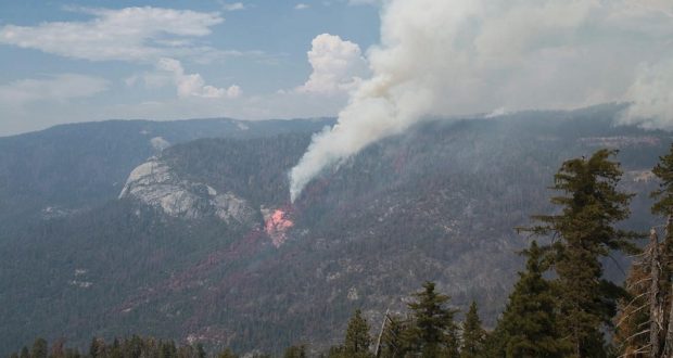
YOSEMITE — The South Fork Fire continues to move away from the community of Wawona as crews strengthen the fireline on the west flank and hold it to the north of the Merced River.
There was no fly-over with updated estimates overnight, so the fire is still estimated at 2,407 acres with 7 percent containment. There are currently 512 personnel assigned to the incident.
There was minimal growth on the fire yesterday as weather conditions and high humidity levels held it within the western and southern containment lines. The fire continues to slowly spread to the northeast into the Yosemite Wilderness.
Air resources are assisting the firefighting efforts as smoke levels allow, however heavy inversions have grounded aircraft until late afternoon. It is when these inversions lift that most visible fire activity occurs.
Direct line construction was tied into Wawona Dome on the west flank yesterday, and burning operations inside that line may begin today if conditions are favorable.
The fire is located in the South Fork drainage of the Merced River, in steep and inaccessible terrain. Crews are hiking in and setting up spike camps in an effort to utilize as much daylight as possible. Pack trains are being considered to support spike crews.
The west flank of the fire is approximately 3/4-mile east of the Swinging Bridge in Wawona. The fire continues to pose a threat to Wawona, the Mariposa Grove, U.S. Forest Service lands and a radio and telecommunications site at Wawona point.
Strategic objectives are to hold the western and southern flanks while monitoring the northern and eastern edges. Minimal Impact Suppression Tactics are being used to manage the fire in the wilderness area, using natural barriers such as rocks or streams, trails, and other minimal disturbance methods to contain the fire.
There remains a threat of thunderstorm activity in the fire area today as a weak low pressure system remains over the region.
The South Central Sierra Interagency Incident Management Team, with Incident Commander Deron Mills, assumed command of the fire at 6 a.m. on Wednesday, Aug. 16. The SCSIIMT is comprised of employees from state and federal agencies, municipalities, and several local resources to support firefighting personnel in their suppression efforts.
There is a voluntary evacuation in place for the Wawona community, and the fire poses no immediate threat at this time.
There is a new live information phone number and email for the South Fork Fire. The phone will be answered from 8 a.m. to 8 p.m. daily at 209-379-5322, or email SouthForkFireInfo@gmail.com
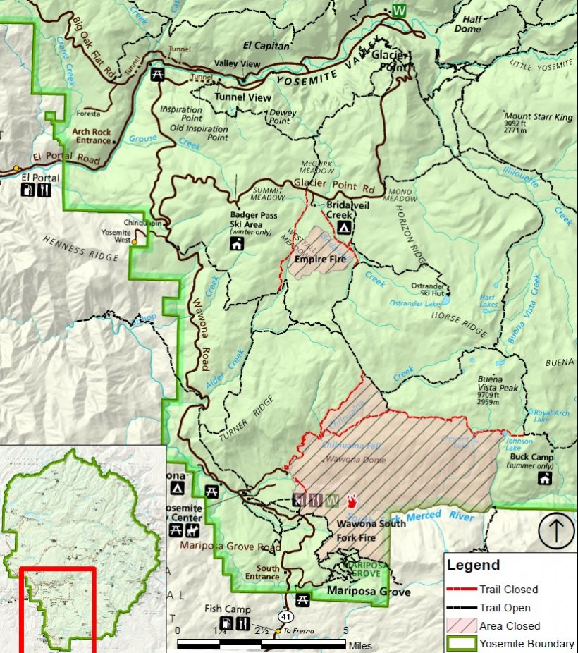
In order to maintain the safety of park visitors and allow fire management operations to continue unimpeded, the Superintendent of Yosemite National Park is designating the following area as closed until further notice is given:
- The Swinging Bridge Trail on both the north and south sides of the South Fork of the Merced River.
- The Chilnualna Falls Trail from Wawona Trailhead to the top of Chilnualna Falls.
- The two mile connecting trail heading north from the top of Chilnualna Falls to the intersection of the Buena Vista Trail.
- The Chilnualna Creek Trail from the top of Chilnualna Falls east to the intersection of the Buena Vista and Buck Camp trails (Just east of Johnson Lake).
- Off-trail areas in the vicinity are closed (i.e. all areas within the shaded circle on the map below).
- All climbing routes on and around Wawona Dome are closed.
“Notice of closure will be posted and area will be monitored to ensure compliance,” say Park officials. “Your cooperation in complying with this temporary restriction is greatly appreciated. The designation will remain in place until rescinded.”
On Wednesday morning, the Office of the Superintendent in Yosemite announced these operational changes:
- Wawona Campground is closed.
- Bridalveil Creek Campground closed on Wednesday morning.
- Wawona trail (mule) rides are not operating.
- Big Trees Golf Course is closed.
- The Badger Pass-Glacier Point shuttle will not operate until further notice as the incident command post is occupying the Yosemite Ski and Snowboard Area facility and parking lot.
- The Glacier Point Road will will remain open to the public however it will close periodically between 10 a.m. and 5 p.m. each day when parking at Glacier Point fills to capacity (and will reopen when sufficient space is available). Traffic delays should be expected.
- A voluntary ban on wood fires is in place in Yosemite Valley to reduce smoke. A mandatory ban may be instituted in the days to come.
The South Fork Fire was reported just after 2 p.m. on Sunday, Aug. 13, and is burning on the South Fork of the Merced River drainage, south of Wawona Dome approximately one mile east of the Swinging Bridge.
Heavy smoke continues to impact Wawona and the areas surrounding Yosemite, especially overnight and through the morning hours, adding more smoke to what is being produced by the Empire Fire near Bridalveil Campground, which is now estimated at 1,400 acres.
Air quality in Wawona is expected to be extremely smoky and to reach unhealthy/ hazardous conditions. Smoke is expected to fill the canyons west of Wawona to Mariposa, and affect visibility along Highway 140 from El Portal to Mariposa, Wawona Road south to Fish Camp, and roads along Tioga Pass to the Mono Lake area.
Some of the agencies assisting on the fire, in addition to the National Park Service, include the U.S. Forest Service, BLM, Cal Fire, Mariposa County Fire, Kern County Fire, and a host of county and city fire departments and federal resources.
The cause of the fire is under investigation.
The estimated date of containment is Sunday, Sept. 3.
For additional information:
- Rapid Notify is a community alert system for rapid event notifications. Register by visiting www.alert.rapid notify.com
- Nixle is a public-safety notification system. Sign up for emergency alerts by texting 95389 to 888-777 or visit their website at www.nixle.com
- Fire Information: Yose_Fire_Info@nps.gov
- Yosemite National Park Fire Information website: http://www.nps.gov/yose/blogs/fireinfo.htm
- Facebook, search: Yosemite Fire and Aviation
- Twitter, search @YosemiteFire : http://www.twitter.com/YosemiteFire
Air quality links for Yosemite National Park:
https://app.airsis.com/USFS/UnitMap
https://www.nps.gov/yose/learn/nature/aqmonitoring.htm
Click here for a perimeter map.
Click here for interactive map.
Trail closure map below.