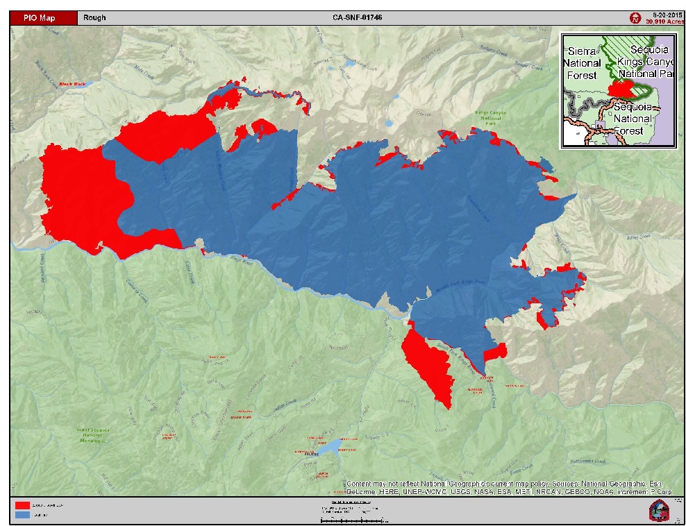
SIERRA NATIONAL FOREST – The Rough Fire, burning 50 miles southeast of Eastern Madera County and north of Hume Lake, continues to challenge fire crews, growing to 32,414 acres with just 3 percent containment.
The size and complexity of the suppression efforts have prompted fire officials to call in an additional Incident Management Team, dividing the fire into two sections, with each team directing operations on their portion of the fire.
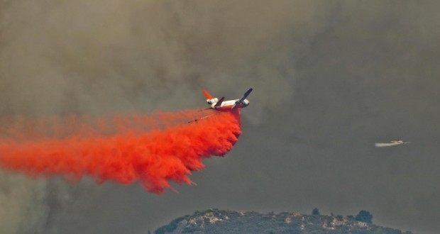
Firefighters worked diligently yesterday to slow the growth of the fire towards Hume Lake. Air resources, including helicopters dropping water, and fixed-wing aircraft using fire retardant, in conjunction with firefighters on the ground, continue working to create firelines.
This morning, as smoke conditions allowed, fixed wing aircraft continued with retardant drops.
Last night, the Incident Command Post that was in Hume Lake was moved to the Hume Ranger Station in Dunlap. The move is to provide continuity of operations for the planning efforts. The firefighters and structure protection resources that were assigned to Hume Lake will continue to remain there to protect that infrastructure.
An additional Incident Management Team will be assisting with the firefighting effort. They will be transitioning at 6 a.m. on Friday and will assume command of the southern half of the Rough Fire.
On the northwest portion of the fire, crews are working to protect the Pacific Gas and Electric infrastructure in the Balch Camp area.
There are currently 1,501 personnel assigned to the incident, including 28 crews, 40 engines and 5 helicopters.
Yesterday, the Fresno County Sheriff’s Office issued evacuation warning notices to residents in the area of Sequoia Highlands. These homes are located northeast of Dunlap in small communities known as Crabtree, Sampson Flat, Davis Flat and Clover Meadows. The people impacted by these warning notices are living / vacationing along the following roads:
U.S. Forest Service Rd. 12S01
U.S. Forest Service Rd. 12S01E
U.S. Forest Service Rd. 12S19
At this time, the roads listed remain open to motorists. The Sheriff’s Office simply wants to alert residents that they should be prepared to leave at a moment’s notice. As fire conditions change all efforts will be made to inform the public.
Closures & Advisories:
• Sequoia & Kings Canyon National Parks issued a closure of the Cedar Grove area.
• Sierra National Forest issued a closure order for the Rough Fire Area.
• Sequoia National Forest issued a closure order for the Hume Lake and Monarch Wilderness.
• Black Rock Campground and Forest Road 11S12 (also called Black Rock Road) is closed between Balch Camp and Sawmill Flat.
• The Hume Lake area is closed, as is Highway 180 beyond Grant Tree Road.
• Forest Advisory for Forest Road 12S01, 12S01E, and 12S19 in the Sequoia Highlands area.
Location:
Kings River Drainage, 5 miles North of Hume Lake and 2.5 miles southwest of Spanish Mountain. The fire is being managed on the Sierra National Forest, Sequoia National Forest, and Sequoia & Kings Canyon National Parks.
The Rough Fire was started by lightning on July 31, and is currently being managed by the South Central Sierra Interagency Incident Management Team.
Fire restrictions are in place for the Sierra National Forest. Campfires are only allowed in designated developed recreation sites. No campfires are allowed within the Sequoia National Forest and Giant Sequoia National Monument.