SIERRA NATIONAL FOREST – Unstable weather is expected in the area of the French Fire overnight, after lower temperatures and higher humidity throughout the day provided some welcome relief.
Planners expect cloudy conditions with potential showers and thunderstorms tonight with light winds, which will be more erratic near any thunderstorms.
So far an estimated 12,827 acres have been burned, and updates on the size of the fire will be provided after an overflight tonight. There are currently 1,813 personnel assigned to the incident.
Containment is now listed at 30%, however it should be noted that the San Joaquin River, which is the fire boundary along most of the eastern edge, has not been included in that number.
Fire officials say they will wait a few days and let that area cool down. The terrain is extremely steep coming up off the river, so with no boots on the ground there, they will wait for the smoke to clear, so to speak, and for the fire that is slowly backing down toward the river to arrive at its destination. At that point, they will consider calling that line contained and including it in the numbers.
The map on the left was created at about 2 a.m. Saturday, Aug. 2, the one on the right just after 9 p.m. the same day, after crews and aircraft had put in a full day of suppression work. The small dots indicate scattered and isolated heat such as stumps or logs, the red areas the intense heat.
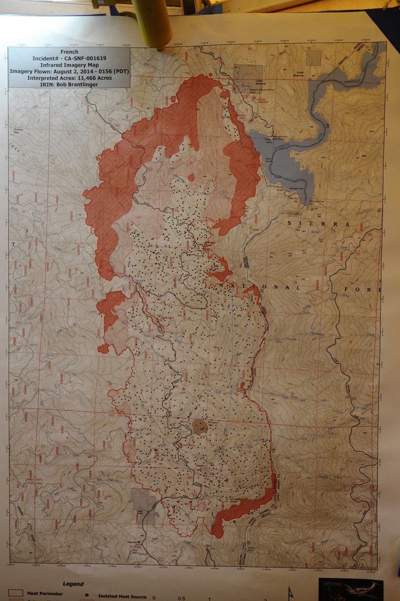
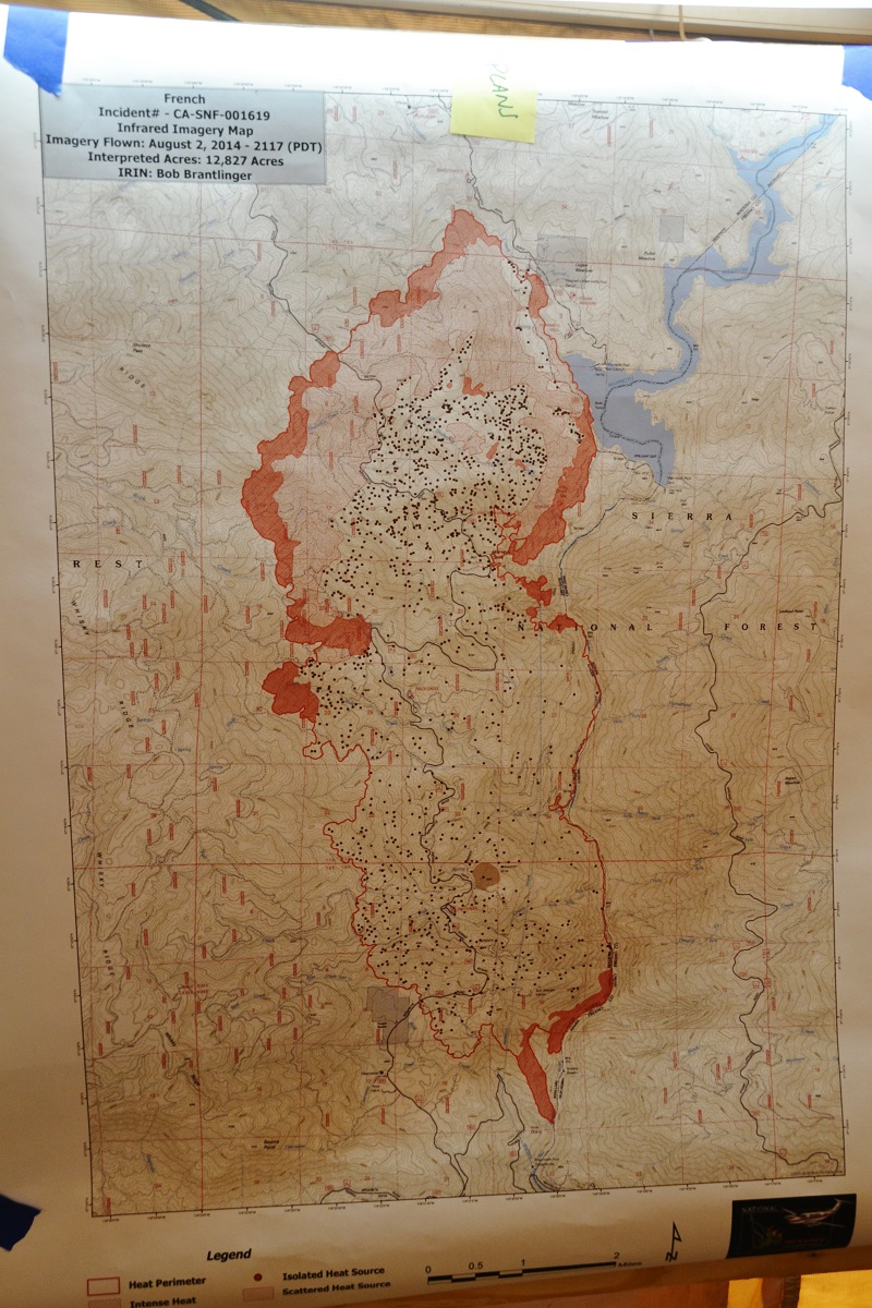 Each night a plane flies over the fire and creates these maps. Each morning, a Cobra helicopter flies the river canyon looking for any signs that the fire has sparked across the river. With last year’s Aspen fire having consumed most of the fuels on the east side, and the subsequent lack of precipitation stunting the growth of new grasses, that risk has been reduced.
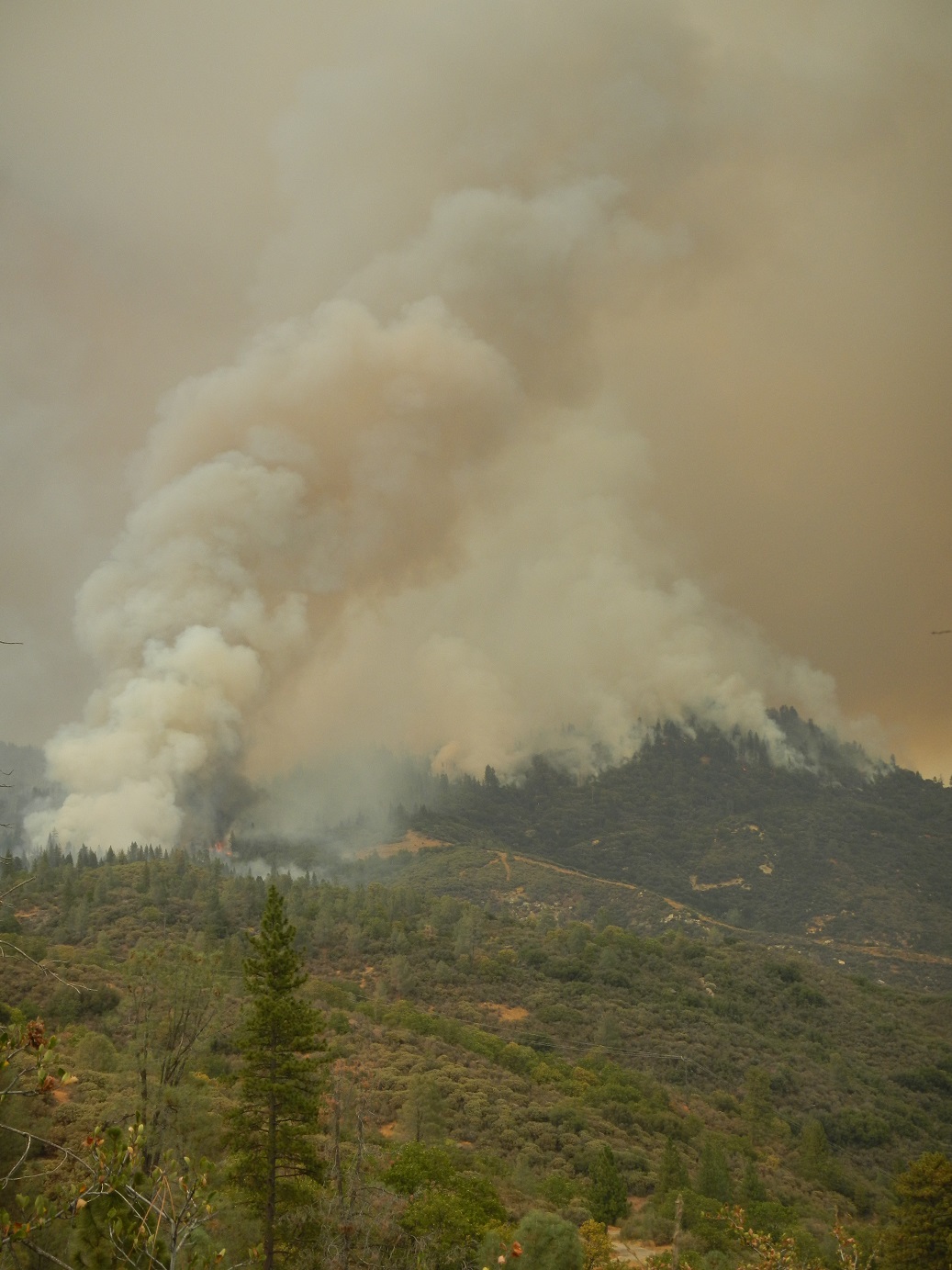
One reason for the increased fire activity on Friday was the heavy concentration of fuels on the northern perimeter. A huge cloud of smoke was visible over the top of the mountains on Friday as the fire moved into dense mixed conifer forests, along with heavy dead and down fuel on the forest floor, creating a lot of heat and smoke.
The most active area of the fire today was the western flank, to the north towards Shuteye Pass. Planners expect this movement to increase as the fire moves into denser fuels. The fire has also moved to the western shore of Mammoth Pool, and is continuing to spread towards Mammoth Pool Dam.
Crews and dozers continued building fireline above the 7S07 Road. To the north and northeast the fire’s spread has been checked with direct line, constructed from Chiquito Creek towards 4S81 (Minarets/Mammoth Pool Road). Another firing operation to secure the area surrounding Wagner’s Store was completed today along Chiquito Creek.
Power has been shut off to the Mammoth Pool area and 12 campgrounds remain evacuated, along with Arnold Meadow. Road closures are still in place.
Structure protection in the Hogue Ranch, Kinsman Flat and Arnold Meadows areas will continue to be the primary objective. The Red Cross activated a shelter on Friday at the Oakhurst Community Center for the residents evacuated from Arnold Meadow, but with only one full-time resident reportedly living there, and the others being seasonal, there was no one in need, and the shelter was closed. They are on alert and ready to go if the need arises, however.
Southern California Edison will be bringing crews in on Tuesday to prepare a lay-down area for the 50-plus new power poles that will be brought in to replace those with fire damage. They will meet tomorrow with safety officers to coordinate their plans, which include about six miles of replacement wire. The poles will have to be set by helicopter, and the company plans to be working on repairs long after the firefighters are gone.
PG&E personnel have been released from the Central Camp area, but will return if conditions change.
 Surveys will begin on dozer lines, and a report prepared on any damage to archeological sites. Those reports will be shared with the North Fork Rancheria of Mono Indians for consultation on how to mitigate effects on traditional gathering places and ancestral lands.
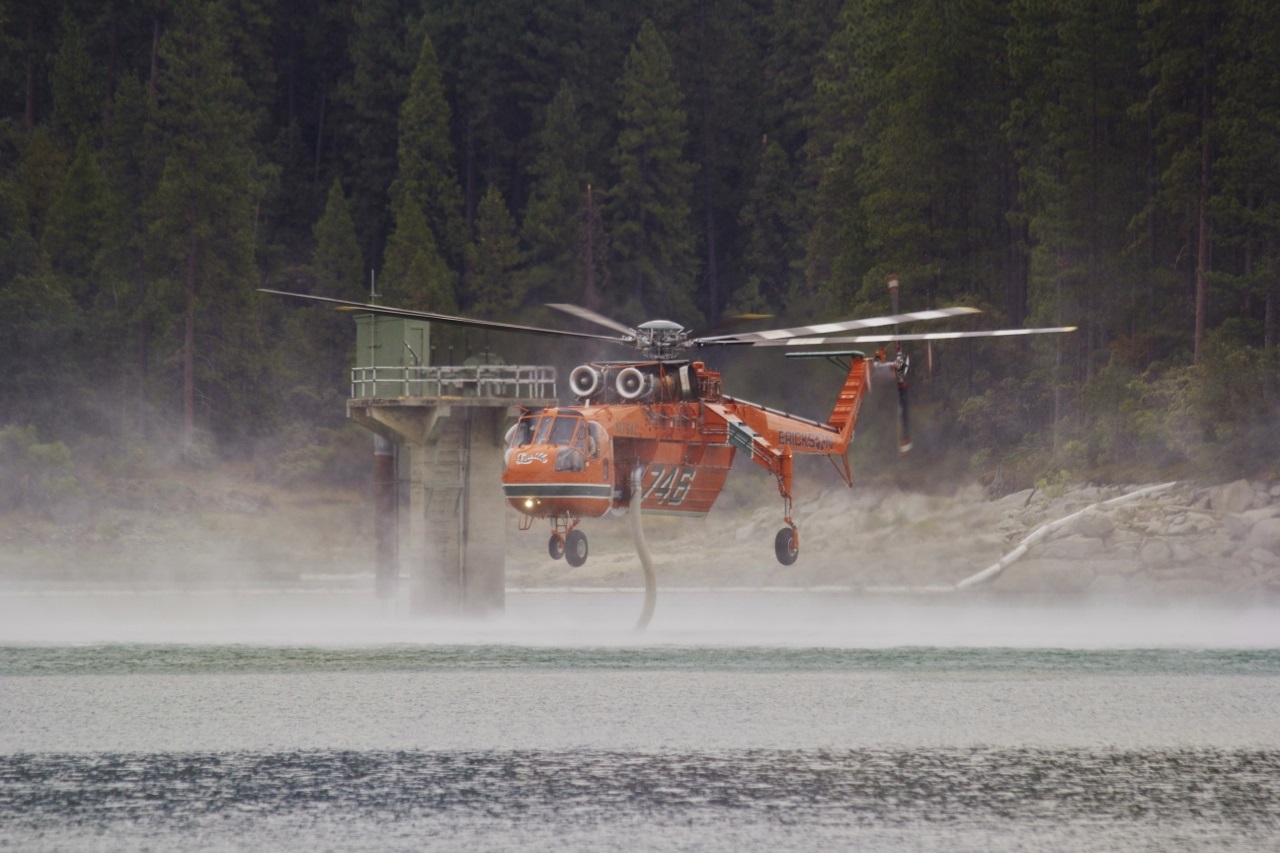
Helicopters dipped water out of Bass lake again today. Sheriff’s patrols kept people out of danger and away from the dam area, and a helitak dip site manager was stationed on the dam, in communication with the aircraft, in case anyone wandered into the operations zone.
Weather was cloudy with much cooler temperatures today of around 80. As a result, winds were fairly light with relative humidity remaining in the 30s all day. Predicted: Cloudy with potential showers/thunderstorms and less smoke as the upper low moves over the area tonight. Winds will be generally light except for erratic winds near any thunderstorms.
An investigation has determined that an abandoned campfire near the Rock Creek Campground was the cause of this fire. Investigators with the Sierra National Forest are asking for the public’s help for information about anyone who was seen in the area of Rock Creek Road near the San Joaquin River on during the afternoon or evening of Sunday July 27.
Anyone with information is encouraged to call the French Fire Information line at 559-877-2605.


We very much appreciate the coverage you have given us on the French Fire. Not much was available on local valley news. Thank you.